Entering the East Sea, storm number 3 has level 14 gusts
(Baonghean.vn) - After entering the East Sea, storm number 3 - storm Ma-on has strengthened with winds near the storm's center reaching level 11, gusting to level 14.
According to the National Center for Hydro-Meteorological Forecasting, at 4:00 a.m. this morning, August 24, the epicenterstorm number 3at about 19.1 degrees North latitude; 118.5 degrees East longitude, in the Northeast area of the East Sea, about 630km Southeast of Hong Kong (China).
The strongest wind near the storm center is level 10 (89-102km/h), gusting to level 13. The radius of strong wind level 6, gusting to level 8 is about 150km from the storm center.
It is forecasted that in the next 24 hours, the storm will move in a West-Northwest direction, traveling 20-25km per hour. At 4:00 a.m. on August 25, the center of the storm will be at about 21.3 degrees North latitude; 113.5 degrees East longitude, in the North East Sea, about 190km South-Southwest of Hong Kong (China). The strongest wind near the center of the storm is level 11 (103-117km/h), gusting to level 14.
Dangerous areas in the East Sea in the next 24 hours (strong winds from level 6 or higher, gusts from level 8 or higher): North of latitude 17.0 degrees North; East of longitude 111.0 degrees East. All vessels operating in the dangerous area are at high risk of being affected by strong winds, big waves and whirlwinds.
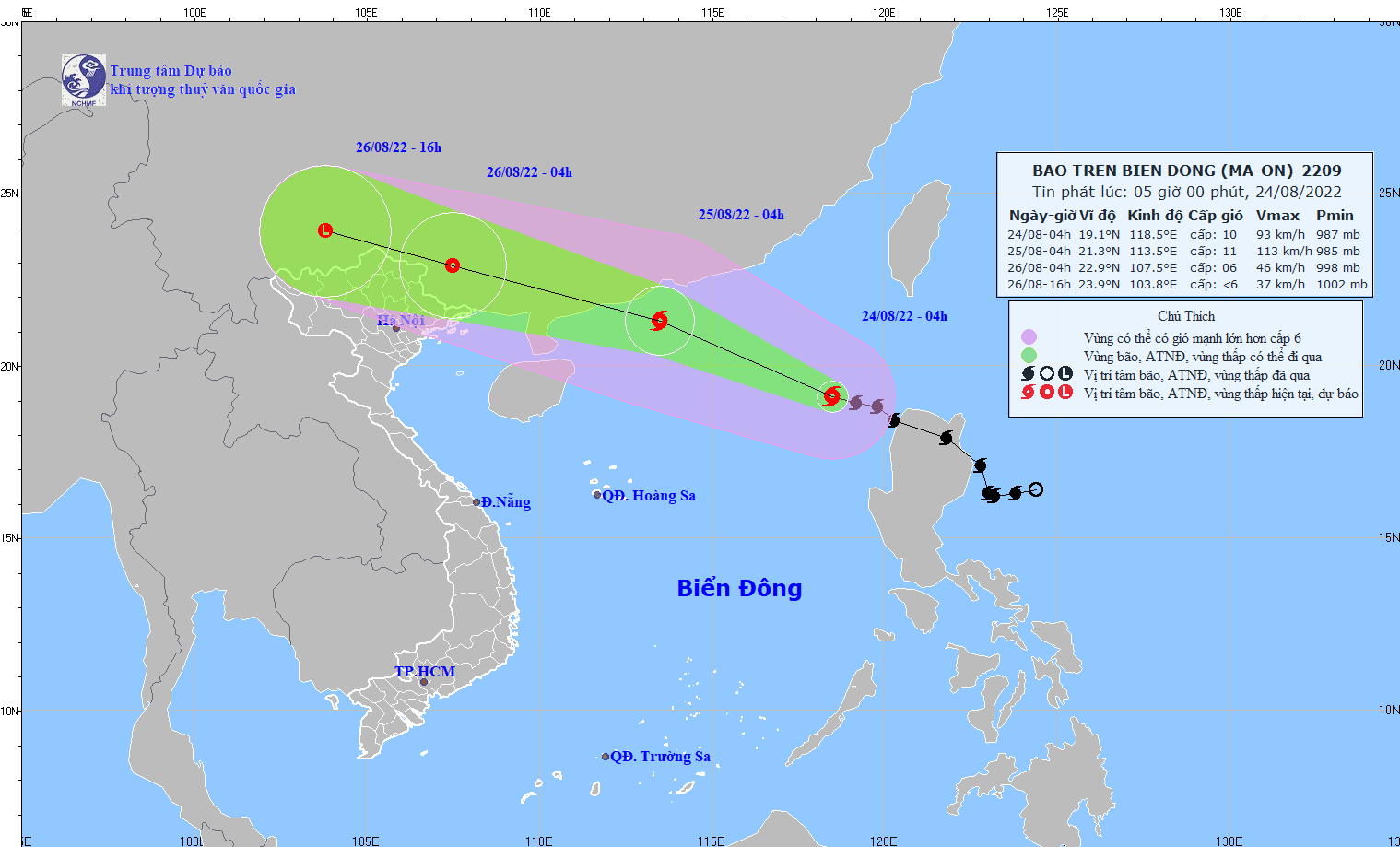 |
After entering the East Sea, storm number 3 - storm Ma-on has strengthened, with wind gusts of level 14. Photo: National Center for Hydro-Meteorological Forecasting. |
In the next 24 to 48 hours, the storm will move west-northwest at 25km per hour and weaken into a tropical depression. At 4am on August 26, the center of the tropical depression will be at about 22.9 degrees North latitude; 107.5 degrees East longitude. The strongest wind near the center of the tropical depression will be at level 6-7 (39-61km/h), gusting to level 8.
The danger zone in the East Sea in the next 24 to 48 hours includes the area north of latitude 19.0 degrees North; from longitude 108.0 to longitude 116.5 degrees East. All vessels operating in the danger zone are at high risk of being affected by strong winds, big waves and whirlwinds.
During the next 48 to 60 hours, the tropical depression will move west-northwest at 20-25km per hour and gradually weaken into a low pressure area. The strongest wind in the center of the low pressure area will decrease to below level 6 (below 39km/h).
Due to the influence of the storm, the eastern sea area of the North East Sea has stormy rain, strong winds of level 6-7, then increasing to level 8-9, near the storm center level 10-11, gusting to level 14; waves from 6.0-8.0m high; rough seas.
According to the National Center for Hydro-Meteorological Forecasting, from the evening and night of August 25 to around August 27, the Northern region and Thanh Hoa will have moderate rain, heavy rain and thunderstorms, and very heavy rain in some places. Localities need to closely monitor the storm's movement to have timely response plans, especially to deal with the risk of landslides and flash floods caused by the storm's circulation.


")


