Storm No. 4 - Bebinca is likely to make landfall in the North Central region.
(Baonghean.vn) - According to the forecast of the National Center for Hydro-Meteorological Forecasting, in the next 48 to 60 hours, the storm will move in the West-Southwest direction, traveling 15-20km per hour, making landfall in the provinces from Hai Phong to Thanh Hoa.
At 4:00 a.m. on August 15,The eye of the storm is located at about 21.1 degrees North latitude; 112.3 degrees East longitude, in the sea south of Guangdong province (China). The strongest wind near the eye of the storm is level 8-9 (60-90km/hour).level 11. The range of strong winds of level 6, gusting to level 8 is about 100km from the center of the storm.
Forecast for the next 24 hours,The storm is moving in a West-Southwest direction, traveling about 10km per hour. At 4:00 a.m. on August 16, the center of the storm was at about 20.5 degrees North latitude; 110.3 degrees East longitude, in the southern area of Leizhou peninsula (China), about 350km east of Hai Phong. The strongest wind near the center of the stormstronggrant8-9(60-90km/h),level 11. The range of strong winds of level 6, gusting to level 8 is about 110km from the center of the storm.
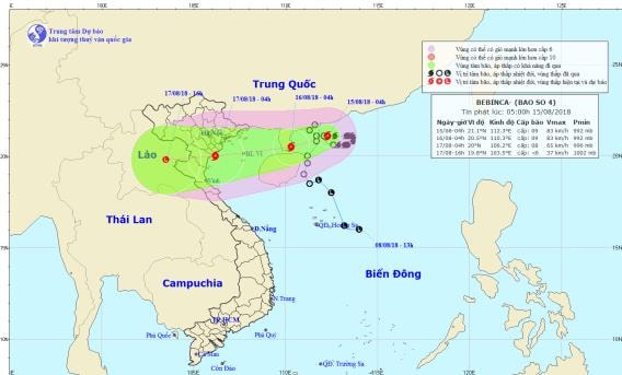 |
| Storm path and location. Photo: National Center for Hydro-Meteorological Forecasting |
Due to the influence of the storm, the North East Sea area has strong winds of level 6; the Northwest of the North East Sea area has stormy rain, strong winds of level 7, the area near the storm center has strong winds of level 8, gusts of level 10. The sea is rough.
Dangerous areas in the East Sea in the next 24 hours (strong wind level 6 or higher): North of latitude 19.5 degrees North; East of longitude 108.5 degrees East.
Over the next 24 to 48 hours,The storm is moving in a West-Southwest direction, traveling about 15km per hour. At 4:00 a.m. on August 17, the center of the storm was at about 20.0 degrees North latitude; 106.2 degrees East longitude, on the coast of Quang Ninh-Thanh Hoa provinces. The strongest wind near the center of the stormstronggrant8(60-75km/h),level 10. The range of strong winds of level 6, gusting to level 8 is about 100km from the center of the storm.
Over the next 48 to 60 hours,The storm moved in the West-Southwest direction, traveling 15-20km per hour, entering the mainland of the provinces from Hai Phong to Thanh Hoa and weakened into a tropical depression. After that, the tropical depression continued to move deeper into the mainland and weakened into a low pressure area in the Upper Laos region. The strongest wind in the center of the low pressure area decreased to below level 6 (below 40km/hour).Storm disaster risk level: level 3.
Heavy rain warning:From the night of August 15 to August 17, there will be heavy to very heavy rain in the Northern and North Central provinces (rainfall 250-350mm/period).
In addition, due to the influence of the tropical convergence zone combined with the strong southwest monsoon, during today and tonight (August 15), in the Central and Southern East Sea (including the waters of Truong Sa archipelago), the sea area from Binh Thuan to Ca Mau will continue to have strong southwest winds of level 6-7, gusting to level 9, waves from 2-4m high; rough seas.
The Gulf of Tonkin, the sea areas from Ca Mau to Kien Giang and the Gulf of Thailand will have heavy thunderstorms; during thunderstorms there is a possibility of tornadoes and strong gusts of wind.Disaster risk level due to strong winds and big waves: level 1.


