Storm No. 4 enters Ha Tinh - Quang Tri, causing heavy rain in Nghe An
(Baonghean.vn) - It is forecasted that in the next 24 hours, the storm will move in the West Northwest direction, traveling about 15km per hour. This evening (July 25), the storm will enter Ha Tinh-Quang Tri and gradually weaken into a tropical depression.
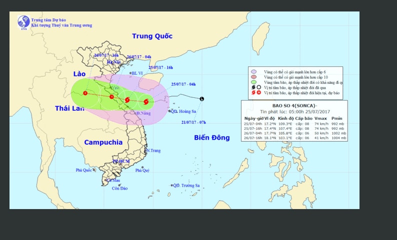 |
| Path of storm No. 4. Photo: North Central Hydrometeorological Station |
According to the latest news from the North Central Hydrometeorological Station, in the past 6 hours, storm number 4 continued to move mainly in a westerly direction.
4 o'clockday 25/07,The eye of the storm is located at about 17.2 degrees North latitude; 109.3 degrees East longitude, about 290km East Southeast of the coast of Ha Tinh-Quang Tri provinces. The strongest wind near the eye of the storm is level 8 (60-75km/hour).jerky9-10.
Forecast for the next 24 hours, the storm is moving in the West Northwest direction, traveling about 15km per hour. This evening (July 25), the storm will enter Ha Tinh-Quang Tri and gradually weaken into a tropical depression. At 4:00 a.m. on July 26, the center of the tropical depression will be at about 17.7 degrees North latitude; 105.8 degrees East longitude, on the Vietnam-Laos border area. The strongest wind near the center of the tropical depression is level 6-7 (40-60km/hour),level 8-9.
In the next 24 hours,danger zone(strong winds of level 6 or higher, rough seas) from latitude 16.00N to 19.50N; west of longitude 111.00E. Areas near the storm center have strong winds of level 8,jerky9-10; waves 3-5m high; rough seas.
Over the next 24 to 36 hours,The tropical depression moved mainly westward, traveling about 15-20km per hour, continuing to move inland and gradually weakening into a low-pressure area in the northeastern region of Thailand.
Weather in the North Central region from July 25 to 26, 2017
Due to the direct impact of storm No. 4:At sea:Wind gradually increases to level 6 - level 7, near the storm center it increases to level 8, gusting to level 9 - level 10.
Wave height: 2.0 - 3.0m; near the storm center, wave height: 3.0 - 5.0m. Very rough seas. Rising water combined with tides in coastal areas from Nghe An to Ha Tinh is 2 - 3m high.
Storm disaster risk level: level 3.
On land:From July 25 to 26, there will be moderate to heavy rain, some places will have very heavy rain and thunderstorms. Strong winds inland at level 5 - level 6, coastal areas at level 7; areas near the storm center will be strong at level 8, gusting at level 9, level 10. Total rainfall for the entire period in Nghe An and Ha Tinh is likely to reach: 100 - 200 mm, in the south over 200 mm in some places; Thanh Hoa: 60 - 120 mm.
Note:Mlarge concentration in short period of time neededyesflash flood and landslide preventionin the midlands and mountains, flooding in low-lying areas./.
Ha Chi
| RELATED NEWS |
|---|


