Storm No. 4 with level 10 gusts will directly affect Nghe An
(Baonghean.vn)- According to the North Central Hydrometeorological Station, storm No. 4 (Sonca) will directly affect Nghe An, causing heavy rain and strong winds.from 25 - 26/7.
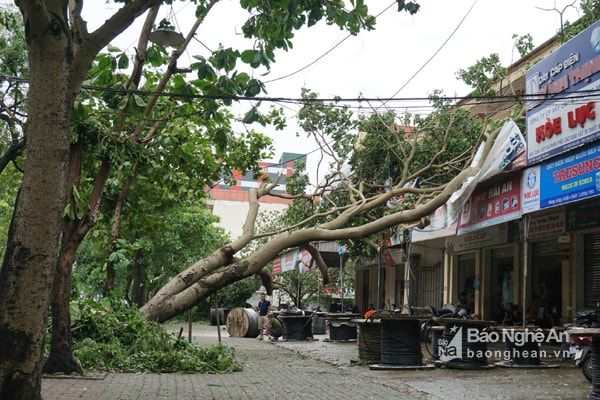
On the afternoon of July 24, Mr. Nguyen Xuan Tien - Deputy Director of the North Central Hydrometeorological Station said that storm No. 4 will directly affect Nghe An.
At 1 p.m. on July 24, the center of storm No. 4 (also known as Sonca) was located at approximately 17.3 degrees North latitude; 110.8 degrees East longitude, approximately 140km southeast of Hainan Island (China). The strongest wind near the center of the storm was level 8 (60-75km/h), gusting to level 9-10.
In the next 24 hours, the storm is forecast to move in a West-Northwest direction, traveling 10-15km per hour. At 10:00 on July 25, the center of the storm was located at about 18.3 degrees North latitude; 108.1 degrees East longitude, in the southern area of the Gulf of Tonkin, about 200km east of the mainland of Thanh Hoa - Quang Binh provinces. The strongest wind near the center of the storm is level 8 (60-75km/hour), gusting to level 9-10.
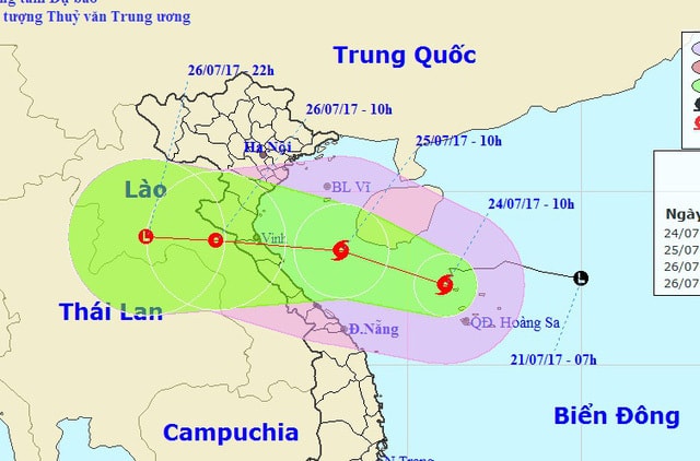 |
| Location and direction of storm number 4. |
In the next 24 to 48 hours, the storm will move in a West-Northwest direction, traveling about 15km per hour, making landfall in the provinces from Thanh Hoa to Quang Binh and weakening into a tropical depression. At 10:00 a.m. on July 26, the center of the tropical depression was at about 18.6 degrees North latitude; 104.5 degrees East longitude, in the Central Laos region. The strongest wind near the center of the tropical depression is level 6 (40 - 50km/hour), gusting to level 7 - 8.
From tomorrow morning (July 25), in the Gulf of Tonkin (including Bach Long Vi island district), the wind will gradually increase to level 6, in the southern area of the Gulf of Tonkin, the wind will increase to level 7, in the area near the storm's center, it will increase to level 8, gusting to level 9-10; waves will be 3-5m high; in the sea areas from Thanh Hoa to Quang Binh, waves will be 2-3m high. The sea will be rough.
During the next 48 to 60 hours, the tropical depression will move mainly in a westerly direction, about 20km per hour, continue to move inland and gradually weaken into a low pressure area over Central Laos.
Storm No. 4 with such a path will directly affect Nghe An. From July 25 to 26, 2017, the storm will cause heavy rain and strong winds.
At sea, there will be moderate rain, heavy rain to very heavy rain and thunderstorms. The wind will gradually increase to level 6 - level 7, near the storm center it will be strong level 8, gusting to level 9 - level 10. Wave height: 1.0 - 2.0m; then gradually increase to: 2.0 - 3.0m; near the storm center, wave height: 3.0 - 5.0m. The sea is very rough. Storm disaster risk level: level 3.
On land from the afternoon of July 25 to the end of July 26, there will be moderate to heavy rain, some places will have very heavy rain and thunderstorms. Storm winds inland will be level 5 - level 6, coastal areas will be level 7 in some places, gusting above level 7. Total rainfall for the entire period is likely to reach: 100 - 200 mm.
 |
| Mr. Nguyen Xuan Tien - Deputy Director of the North Central Hydrometeorological Station said that storm No. 4 with such a path will directly affect Nghe An. Photo: Tran Chau |
Faced with the above situation, people need toRegularly monitor and update storm forecasts broadcast on mass media to take appropriate preventive measures.
At sea, in the next 24 hours, ships and boats must move away from the dangerous area (strong winds of level 6 or higher, rough seas) from latitude 16.50N to 20.00N; west of longitude 113.00E. The area near the storm center will have strong winds of level 8, gusts of level 9-10; waves from 3-5m high; rough seas. It is necessary to regularly monitor the storm's path forecast to escape the dangerous area.
On land, measures should be taken to prevent strong winds such as pruning trees, bracing houses and structures. Especially coastal and mountainous areas should be on guard against flash floods and landslides; low-lying and urban areas should be on guard against flooding.
 |
| Nghe An is the province that suffered the most damage after storm No. 2. Photo: Tien Hung |
Nghe An was the province most severely damaged by storm No. 2, with 136 houses completely collapsed and nearly 9,000 houses having their roofs blown off or damaged. Nearly 1,500 kiosks and shops were damaged, hundreds of other houses had their roofs crushed by trees, or had landslides. Many educational and medical facilities, cultural houses, traffic and irrigation works... were also severely damaged after storm No. 2. Heavy rains caused by the storm flooded tens of thousands of hectares of crops. More than 300 livestock and 25,000 poultry were killed and swept away. 1 fishing boat, 3 small boats were sunk, dozens of hectares of shrimp ponds were damaged... As of July 21, 2017, the total damage caused by storm No. 2 in Nghe An province was estimated at over VND993 billion; of which, agricultural production was nearly VND574 billion, infrastructure was over VND420 billion. |
Pearl - Ngoc Anh
| RELATED NEWS |
|---|
")

.png "Nghệ An chủ động ứng phó áp thấp có khả năng mạnh lên thành áp thấp nhiệt đới, mưa lớn, nguy cơ lũ quét, sạt lở đất")

.jpg "Nghệ An chỉ đạo các biện pháp chủ động ứng phó với mưa lớn, nguy cơ gây ngập lụt, lũ quét, sạt lở đất")

