Warning: Low pressure in the East Sea has strengthened into storm BEBINCA with level 10 gusts
(Baonghean.vn) - It is forecasted that in the next 24 hours, the storm will move in an East Southeast direction, traveling about 5km per hour and may strengthen further.
This morning (August 13), the tropical depression in the sea south of Guangdong province (China) strengthened into a storm, storm number 4 in 2018 (international name: BEBINCA).
At 7 o'clock,The center of the storm is located at approximately20.6 degrees North latitude; 112.8 degrees East longitude, on the sea south of Guangdong province (China). The strongest wind near the storm center is level 8 (60-75km/hour),level 10. The range of strong winds of level 6, gusting to level 8 is about 90km from the center of the storm.
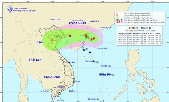 |
| Storm path and location. Photo: National Center for Hydro-Meteorological Forecasting |
Forecast for the next 24 hours,The storm is moving in an East Southeast direction, about 5km per hour and is likely to strengthen. At 7:00 a.m. on August 14, the center of the storm was located at about20.8 degrees North Latitude;113.3 degrees East longitude, in the sea south of Guangdong province (China). The strongest wind near the storm centerstronggrant8(60-75km/h),level 10. The range of strong winds of level 6, gusting to level 8 is about 100km from the center of the storm.
Dangerous areas in the East Sea in the next 24 hours (strong wind level 6 or higher): North of latitude 19.0 degrees North; East of longitude 110.5 degrees East.
Over the next 24 to 48 hours,The storm is moving in a West Northwest direction, traveling about 5km per hour. At 7:00 a.m. on August 15, the center of the storm was at about 21.4 degrees North latitude; 111.7 degrees East longitude, right above the southern coastal area of Guangdong province (China). The strongest winds near the center of the stormstronggrant8-9(60-90km/h),level 11. The range of strong winds of level 6, gusting to level 8 is about 120km from the center of the storm.
During the next 48 to 72 hours,The storm is moving in a West-Southwest direction, traveling about 10km per hour. At 7:00 a.m. on August 16, the center of the storm was at about 21.3 degrees North latitude; 108.5 degrees East longitude, in the northern area of Bac Bo Gulf, about 120-150km from the coast of the provinces from Quang Ninh to Nam Dinh. The strongest wind near the center of the stormstronggrant8(60-75km/h),level 10. The range of strong winds of level 6, gusting to level 8 is about 100km from the center of the storm.Storm disaster risk level: level 3.
Heavy Rain Warning:On August 14-15, there will be scattered rain in the North. From the night of August 15 to August 17, there will be heavy to very heavy rain in the Northern and North Central provinces (rainfall 250-350mm/period).
In addition, due to the influence of the tropical convergence zone combined with the strong southwest monsoon, during the day and tonight (August 13), in the Central and Southern East Sea (including the waters of Truong Sa archipelago), the waters from Binh Thuan to Ca Mau will continue to have strong southwest winds at level 6, gusting to level 8, waves from 2-4m high; rough seas.
The Gulf of Tonkin, the sea areas from Binh Thuan to Ca Mau, Ca Mau to Kien Giang and the Gulf of Thailand will have heavy thunderstorms; there is a possibility of tornadoes and strong gusts of wind during thunderstorms.Disaster risk level due to strong winds and big waves: level 1.
FLOOD, FLASH FLOOD AND LANDSCAPE WARNING IN THE NORTHERN REGION
On August 14-15, there will be scattered rain in the North. From the night of August 15 to August 17, there will be heavy to very heavy rain in the Northern and North Central provinces (rainfall 250-350mm/period).
Warning:
From August 16-17, on the Red River - Thai Binh River system, Hoang Long River will experience a flood with a flood amplitude of 2-4m. During this flood, the flood peak on Da River, Thao River, Hoang Long River, Bui River is likely to reach level 2-3; the upper Thai Binh River is at level 1.
There is a high risk of landslides and flash floods in the northern mountainous areas, especially in the provinces of Lai Chau, Son La, Hoa Binh, Yen Bai, Phu Tho, Quang Ninh, Lang Son and Cao Bang. Flooding in low-lying areas is likely to occur, especially in the Northern Delta region.
(NeedcAttention followDetailed flash flood and landslide warning information to district level in flash flood and landslide warning bulletins)
Warning level of natural disaster risk due to floods, flash floods, landslides in mountainous areas of the North: level 1.


