Update on storm number 4: From the night of August 29 to September 1, Nghe An will have very heavy rain
(Baonghean.vn) - Due to the influence of storm No. 4, from the night of August 29 to September 1, there will be moderate rain, heavy rain to very heavy rain; Particularly in the south of Nghe An and Ha Tinh, there will be places with especially heavy rain and thunderstorms.
13:00 on August 28, the center of the storm is located at about 17.0 degrees North latitude; 116.0 degrees East longitude, about 450km east of Hoang Sa archipelago. The strongest wind near the center of the storm is level 8 (60-75km/hour),level 10. Radius of strong winds level 6, gusting to level 8 or higher about 100km from the center of the storm.
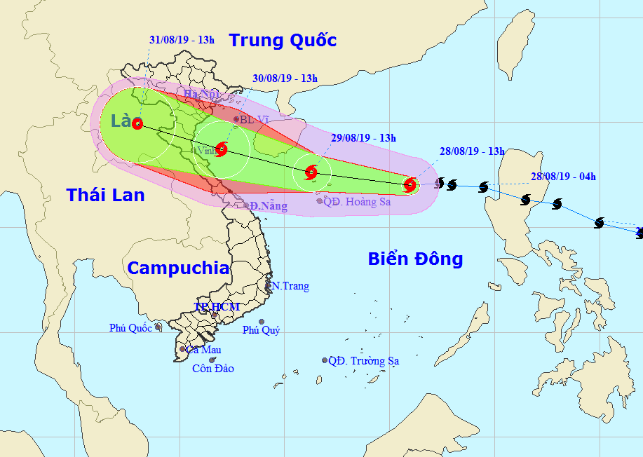
Forecast for the next 24 hours,The storm is moving westward at about 25km per hour and is likely to strengthen. At 1pm on August 29, the storm's center was at about 17.6 degrees North latitude; 111.3 degrees East longitude, about 180km southeast of Hainan Island. The strongest wind near the storm's center is level 9 (75-90km/hour).level 11.
Dangerous areas in the East Sea in the next 24 hours(strong wind level 6, gust level 8 or higher)): North of latitude 15.0 degrees North.
Over the next 24 to 48 hours,The storm is moving mainly in the West-Northwest direction, traveling about 15km per hour and is likely to strengthen. At 13:00 on August 30, the center of the storm was at about 18.7 degrees North latitude; 107.0 degrees East longitude, right on the sea of the provinces from Thanh Hoa to Quang Binh. The strongest wind near the center of the storm is level 9-10 (75-100km/hour).level 12.
Over the next 48 to 72 hours,The storm is moving in the West Northwest direction, traveling about 20km per hour, around the afternoon to evening of August 30, it will make landfall in the provinces from Thanh Hoa to Quang Binh with strong winds of level 8-9, gusting to level 11, then weaken into a tropical depression. At 13:00 on August 31, the center of the tropical depression was at about 19.9 degrees North latitude; 103.0 degrees East longitude, in the Upper Laos area. The strongest wind near the center of the tropical depression is strong at level 6 (40-50km/hour),level 7.
* Strong wind warningin the North Central region
+ At sea:
From the morning of August 30, the sea area from Thanh Hoa to Ha Tinh has gradually increased in strength to level 9 - level 10, gusting to level 11.
+ On land:
Due to the direct impact of storm No. 4, from the afternoon and night of August 30, from Thanh Hoa to Ha Tinh, the wind will gradually increase to level 6 - level 7; then increase to level 8 - level 9, gusting to level 11.
* Heavy rain warningin the North Central region:
From the night of August 29 to September 1, there will be moderate to heavy rain; In particular, in the south of Nghe An and Ha Tinh, there will be places with especially heavy rain and thunderstorms (the total rainfall is likely to reach 150 - 350mm, in the south of Nghe An and Ha Tinh, there will be places with over 400mm).
Thunderstorms are likely to produce tornadoes, lightning, hail and strong winds.
High risk of flash floods, floods due to blocked waterways, mudslides, landslides in mountainous areas, and flooding in low-lying areas in provinces from Thanh Hoa to Ha Tinh.
Storm disaster risk level: level 3


