Nghe An is experiencing heavy rain; be prepared for thunderstorms and hailstorms.
(Baonghean.vn) - Due to the influence of a tropical depression, it is forecast that from tonight until tomorrow (June 30), Nghe An will experience moderate to heavy rain, with a risk of thunderstorms, hail, and strong gusts of wind.
According to the North Central Region Meteorological and Hydrological Station, currently, a low-pressure trough with its axis passing through Northern Vietnam is connected to a tropical depression in the East Sea; a convergence zone of winds up to 5000m has formed over the mountainous areas of Northern Vietnam.
 |
| The path of the tropical depression over the South China Sea. |
The forecast from tonight until tomorrow (July 30th) indicates moderate to heavy rain in Thanh Hoa, with some areas experiencing heavy rainfall.very heavy rain and thunderstormsWith rainfall generally ranging from 40-80mm/24h, and in some areas exceeding 100mm/24h.
In Nghe An province, rainfall is generally 30-60mm/24h, with some districts experiencing higher amounts exceeding 80mm/24h, such as Quy Chau, Quy Hop, Nghia Dan, and Quynh Luu.
Warning: Around July 2nd-3rd, the rain will gradually decrease, then it may return and the situation may become complicated in the following days due to the influence of the circulation.tropical depressionDuring thunderstorms, there is a high probability of tornadoes, lightning, and strong gusts of wind; heavy rainfall concentrated in a short period of time poses a high risk of flash floods and landslides in the midland and mountainous areas, and flooding in low-lying areas.
Warning of natural disaster risk level due to heavy rain, tornadoes, lightning, and strong winds: Level 1.
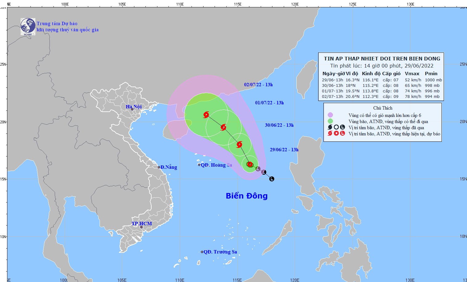
NEWS ON TROPICAL DEPRESSION IN THE SOUTH CHINA SEA
At 13:00 on June 29th,The center of the tropical depression is located at approximately 16.3 degrees North latitude and 116.1 degrees East longitude, about 480km east of the Hoang Sa (Paracel) Islands. The strongest winds near the center of the tropical depression are at force 6-7 (39-61 km/h), with gusts up to force 9. The radius of strong winds at force 6, with gusts up to force 9, is approximately 100km from the center of the tropical depression.
Forecast for the next 24 hoursThe tropical depression is moving in a north-northwest direction at a speed of 5-10 km per hour and has the potential to strengthen into a typhoon.
By 1 PM on June 30thThe storm's center is located at approximately 18.0 degrees North latitude and 115.2 degrees East longitude, about 420km east-northeast of the Hoang Sa (Paracel) Islands. The strongest winds near the storm's center are at level 8 (62-74 km/h), with gusts up to level 10.
Storm hazard zone in the South China Seain the next 24 hours(Strong winds of force 6 or higher, gusts of force 8 or higher): from latitude 15.0 to 19.5 degrees North; from longitude 113.0 to 117.5 degrees East. All vessels operating in this dangerous zone are at high risk of being affected by strong gusts of wind and high waves. Disaster risk level: level 3.
Over the next 24 to 48 hoursThe storm is moving mainly northwest at a speed of about 10 km per hour and continues to intensify.
By 1 PM on July 1stThe storm's center is located at approximately 19.5 degrees North latitude and 113.8 degrees East longitude, about 410km north-northeast of the Hoang Sa (Paracel) Islands. The strongest winds near the storm's center are at level 8 (62-74 km/h), with gusts up to level 10.
Over the next 48 to 72 hoursThe tropical depression is moving northwest at a speed of about 10 km per hour and has the potential to strengthen into a typhoon.
Warning of strong winds and high waves at sea:Due to the influence of a tropical depression, which may later strengthen into a storm, strong winds of force 6-7, later increasing to force 8 with gusts up to force 10, are expected in the eastern part of the North East Sea; sea waves will be 3.0-5.0m high, with rough seas. In the sea area from Binh Thuan to Ca Mau, and in the Central and Southern East Sea (including the Truong Sa archipelago), southwest winds will gradually strengthen to force 5, later increasing to force 6 with gusts up to force 7-8; sea waves will be 2.0-3.0m high, with rough seas.

