Nghe An at risk of flash floods, landslides, and inundation
(Baonghean.vn) - In the next 3-6 hours, there is a high risk of flash floods, landslides and inundation in low-lying areas in Nghe An province. Especially in the districts of Con Cuong, Quy Hop, Do Luong and Thanh Chuong.
According to the National Center for Hydro-Meteorological Forecasting, in the past 3 hours in Thanh Hoa and Nghe An, there have beenmoderate rain, heavy rain, very heavy rain in some places such as Yen Khuong 40mm, Yen Thanh 60mm, Hong Son 90mm, Thanh Huong 60mm. It is forecasted that in the next 3-6 hours, there will continue to be moderate rain, heavy rain.
Warning:In the next 3-6 hours, there is a high risk of flash floods, landslides and inundation in low-lying areas in Thanh Hoa and Nghe An provinces. Especially in the districts of Con Cuong, Quy Hop, Do Luong, Thanh Chuong (Nghe An); Nhu Xuan, Nhu Thanh, Thuong Xuan, Quan Hoa, Ba Thuoc, Cam Thuy (Thanh Hoa).Disaster risk level: Level 1.
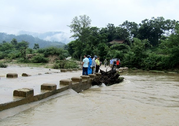 |
| Floodwaters have flooded many bridges, posing a danger to people traveling at these points. In the photo is Ban Lim Bridge, Chau Phong Commune, Quy Chau. Photo courtesy: Be Vinh |
NEWS ON TROPICAL LOW PRESSURE SYSTEM ON LAND (WEAKED FROM STORM NO. 03)
Last night (July 18),Storm No. 3 made landfall in Thanh Hoa and Nghe An provinces and weakened into a tropical depression. Due to the storm's influence, since yesterday afternoon and night, Thanh Hoa, Nghe An and Ha Tinh have had heavy to very heavy rain (70-150mm); along the coast of the provinces from Thai Binh to Ha Tinh, there have been strong winds of level 6, gusts of level 7-8; Hon Ngu island in particular has strong winds of level 7, gusts of level 9; Tinh Gia and Ngoc Tra (Thanh Hoa) have gusts of level 9.
At 4:00 a.m. on July 19, the center of the tropical depression is located at about 19.0 degrees North latitude; 105.2 degrees East longitude, on the mainland of Nghe An and Thanh Hoa provinces. The strongest wind near the center of the tropical depression is level 6-7 (40-60km/hour),level 8-9
Forecast for the next 12 hours, the tropical depression moved westward, traveling 20-25km per hour, moving deep into the mainland and gradually weakening into a low pressure area. By 4:00 p.m. on July 19, the center of the low pressure area was at about 19.5 degrees North latitude; 102.0 degrees East longitude, on the mainland of Central Laos. The strongest wind in the center of the low pressure area decreased to below level 6 (below 40km/hour).
Due to the influence of low pressure, early this morning in the Gulf of Tonkin there are strong winds of level 6-7,level 8-9, waves 2-4m high; rough sea.
On land, in the provinces of Thai Binh, Nam Dinh, Ninh Binh, Thanh Hoa, Nghe An and Ha Tinh, early this morning there will be strong winds of level 6.level 7-8.Disaster risk level: level 3.
Heavy rain warningFrom now until July 21, in the North and North Central regions, there will continue to be moderate to heavy rain. On July 19-20, in the delta and midland provinces of the North, and provinces from Thanh Hoa to Ha Tinh, there will be very heavy rain.
Flood warningFrom now until July 20, there will be a flood on the upper reaches of the Red River - Thai Binh, Hoang Long River, and rivers from Thanh Hoa to Ha Tinh. The flood level on the rivers is as follows: the upper reaches of the Red River - Thai Binh from 2-4m; Hoang Long River from 1-2m; and rivers from Thanh Hoa to Ha Tinh from 3-5m.
During this flood, the flood peak on the Da River reached level 1; Thao River, Lo River, Hoang Long River and rivers in Thanh Hoa, Nghe An, Ha Tinh reached level 1-2.Warning level of natural disaster risk due to floods, flash floods, landslides: level 2.
Widespread heavy rain in the North and North Central regions
Due to the influence of the strong tropical convergence zone combined with the circulation of storm No. 3, last night (July 18), in the Northern, North Central and Central Central provinces, there was rain, moderate rain, and heavy rain in some places with common rainfall of 10-50mm. In particular, Thanh Hoa, Nghe An and Ha Tinh had very heavy rain with common rainfall of 50-80mm.
Currently (July 19):The tropical convergence zone with its axis passing through the North Central region is active, connecting with the weakened tropical depression from storm No. 3, located at 1:00 a.m. this morning at about 18.9 degrees North latitude, 105.7 degrees East longitude.
Forecast:Today and tonight (July 19), due to the impact of storm No. 3, in the plains and midlands of the North, the provinces of Yen Bai, Hoa Binh, Son La, Thanh Hoa, Nghe An, Ha Tinh will have heavy to very heavy rain. From tomorrow (July 20), heavy rain is likely to spread to the mountainous provinces of the North and the Northwest of the North.
Warning:Heavy rain in the Northern and Central provinces is likely to last for many days to come. Pay attention to the next heavy rain forecast bulletins.Disaster risk level due to heavy rain: level 1; Thanh Hoa, Nghe An, Hoa Binh, Son La, Yen Bai provinces: level 2.
Thunderstorms in the Central Highlands and the South
The Central Highlands and the South are affected by the strong southwest monsoon, so in the next 2-3 days there will continue to be rain, moderate rain, heavy rain and thunderstorms in some places (rain is concentrated in the afternoon and night); during thunderstorms there is a very high possibility of tornadoes, whirlwinds and strong gusts of wind.
.jpg "Thời tiết Nghệ An ngày 25/9: Có mưa vừa đến mưa to, có nơi mưa rất to và dông")


.jpg "Gia cố ao hồ nuôi trồng thuỷ sản phòng ngập do mưa to")