What is called a super typhoon?
(Baonghean.vn) - There are many ways to calculate the wind level in the air disturbance in the West Pacific. The following understanding is considered common and is often applied by reliable meteorological agencies such as Japan, Hong Kong and the US.
1. Distinguishing storm levels:According to the regulations of the storm committee in the West Pacific (the area with Vietnam), wind speed does not exceed 63km/h, it is called a tropical depression; Wind speed from 63-88km/h: tropical storm; Wind speed from 89-117km/h: severe tropical storm; Wind speed from 118km/h or more: typhoon.
 |
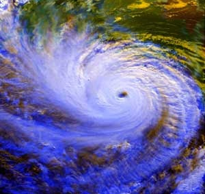
| Satellite cloud image of a storm. |
Also in the Western Pacific region, but according to the regulations of the US Navy Joint Typhoon Warning Center located in Guam, when a storm reaches wind speeds above 115 knots (213 km/h), it is called a super typhoon.
For the Saffir-Simpson scale for the Atlantic and Eastern Pacific, when the storm is above 117km/h, it is divided into 5 levels of wind strength. Accordingly, at level 1, the maximum wind speed is between 118 - 153km/h, level 2 (154-177km/h), level 3 (178-209km/h), level 4 (210-249km/h), and level 5 (over 250km/h) is called a "super typhoon" because the wind speed exceeds 249km/h. Another regulation is that when the pressure reaches below 920 HPA, it is classified as a super typhoon.
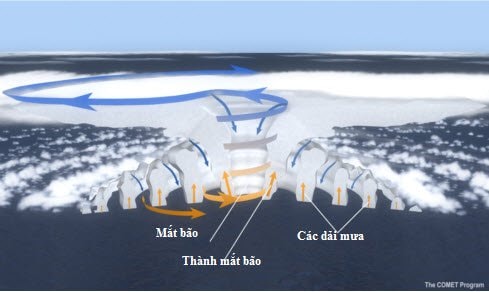 |
| Storm structure diagram with basic components: storm eye, eyewall and spiral rain bands. |
2. Structure of the storm:The main components of a hurricane include the rain bands at the outer edges, the eye in the center, and the eyewall immediately adjacent to the eye. In the lower half of the atmosphere, air spirals counterclockwise into the center, moves vertically upward in the eyewall, and radiates outward at the top in the opposite direction. In the center of the hurricane, air descends, creating a clear zone in the eyewall.
3. Eye of the storm:The eye of a storm is a relatively calm, cloudless area, about 30-60 km in diameter. When in the storm area, people are often surprised to see the wind and rain that have been very fierce suddenly stop, the sky is clear and the clouds have stopped, that is when the eye of the storm has passed.
4. Eye of the storm:It is the thick wall of clouds surrounding the eye of the storm consisting of very high developing thunderclouds. This is where the strongest winds in the storm occur.
 |
| Eye of the storm. Illustration photo |
5. Spiral rain bands:The outer rain bands of a storm can extend hundreds of kilometers from the center of the storm. These dense, slow-moving, counterclockwise-spiraling bands of thunderstorm clouds range in width from a few kilometers to tens of kilometers and are 80 to 500 kilometers long.
6. Size of the storm:The typical size of a hurricane is a few hundred kilometers, but can vary considerably. The size of a hurricane does not necessarily indicate its intensity./.
Kim Ngoc
(Synthetic)
| RELATED NEWS |
|---|


.jpg "Mặt trận Tổ quốc Việt Nam tỉnh Nghệ An kêu gọi ủng hộ đồng bào bị thiệt hại do bão số 10")


