Latest information on storm number 3 heading towards land
(Baonghean.vn) - At 10:00 a.m. on July 18, the center of the storm was at about 18.7 degrees North latitude; 108.8 degrees East longitude, about 330km east of the mainland provinces from Thanh Hoa to Quang Binh. The strongest wind near the center of the storm was level 8-9 (60-90km/h), gusting to level 11.
Forecast for the next 24 hours, the storm moves quickly to the West, about 25-30km per hour;In the evening and tonight (July 18), the storm center with strong winds of level 8, gusting to level 10 will directly affect coastal areas of provinces from Thai Binh to Quang Binh.The storm will then move inland and weaken into a tropical depression..At 10:00 a.m. on July 19, the center of the tropical depression was at about 19.1 degrees North latitude; 103.2 degrees East longitude, in the Upper Laos region. The strongest wind speed in the area near the center of the tropical depressionlevel 6 strong(40-50km/hour),level 8 jerk.
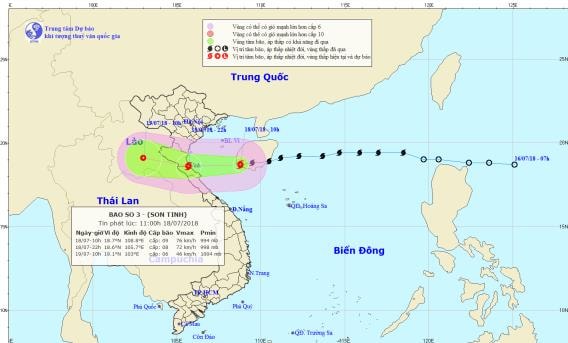 |
| Path and location of storm No. 3. Photo: National Center for Hydro-Meteorological Forecasting |
Due to the influence of the storm, in the Gulf of Tonkin, the wind gradually increased to level 7, the area near the storm's eye had strong winds of level 8-9.level 11, waves 3-5m high; very rough seas. Coastal areas of the Northern Delta and North Central Coast are likely to see sea levels rise above the tidal range by about 0.5-0.7m; waves 2-4m high; very rough seas.
From this afternoon (July 18), on the mainland of Thai Binh, Nam Dinh, Ninh Binh, Thanh Hoa, Nghe An, Ha Tinh and Quang Binh provinces, the wind will gradually increase to level 6, then increase to level 7, gusting to level 9; in particular, South Thanh Hoa, Nghe An and Ha Tinh will have strong storm winds of level 8,level 11.
Forecast for the next 24 to 36 hours, the tropical depression continued to move west, weakening and gradually dissipating.Storm disaster risk level: level 3.
From noon today, in the provinces of the Northern Delta and midlands, the provinces from Thanh Hoa to Quang Binh will have very heavy rain and it will last until about July 20 (common rainfall 100-300mm/period, some places over 350mm).
Warning: From July 18-20, a flood will appear in the upper reaches of the Red-Thai Binh river system, Hoang Long river, and rivers from Thanh Hoa to Ha Tinh. The flood peak on the Da river, Thao river, Hoang Long river, and the upper reaches of rivers in Thanh Hoa, Nghe An, and Ha Tinh will reach level 1-2, the Buoi river (Thanh Hoa) will be above level 2; the lower reaches of the main rivers in Thanh Hoa, Nghe An, and Ha Tinh will be below level 1.
High risk of landslides and flash floods in mountainous areas of the northern provinces and provinces from Thanh Hoa to Ha Tinh (details in flood bulletins, flash flood and landslide warnings).Warning level of natural disaster risk due to floods, flash floods, landslides: level 2.

.jpg "Nghệ An: Lễ khai giảng đặc biệt ở xã biên giới bị thiệt hại nặng nề nhất sau bão số 3")


: cách Nghệ An khoảng 185km về phía Đông Đông Nam")
.jpg "Gần 5 tỷ đồng hỗ trợ học sinh Nghệ An bị ảnh hưởng bão số 3")
.jpg "Cán bộ Sở Nội vụ Nghệ An về xã miền núi hỗ trợ giải quyết kịp thời chế độ, chính sách cho cán bộ nghỉ việc")