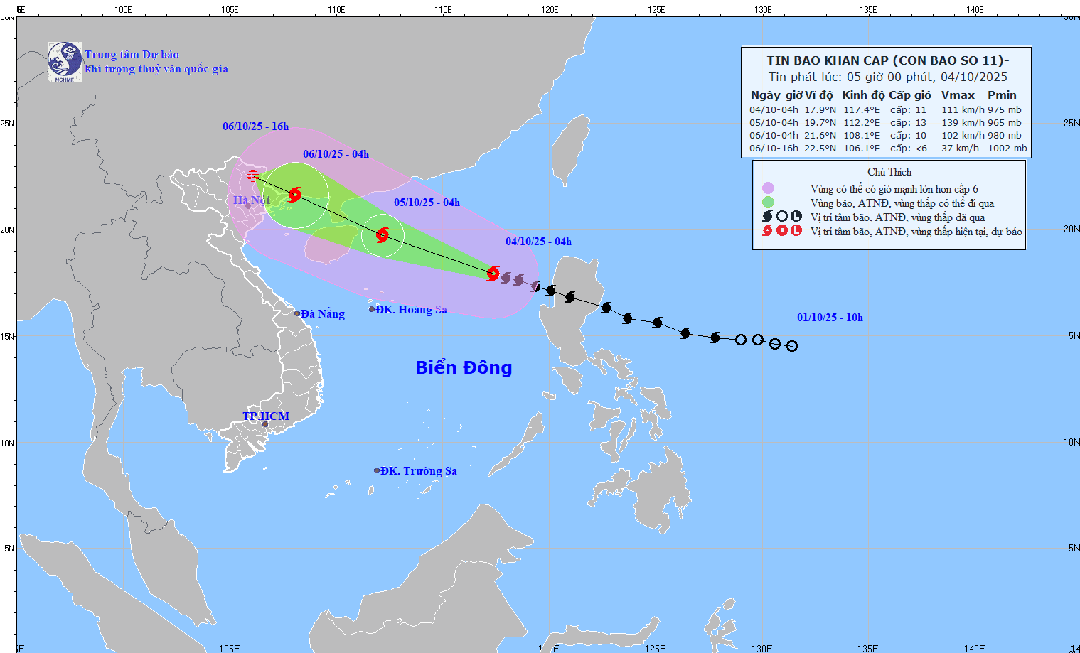
URGENT STORM NEWS (Storm No. 11): At 4:00 a.m. on October 4, the center of the storm was about 570km East-Northeast of Hoang Sa special zone.
At 4:00 a.m. on October 4, the center of the storm was at about 17.9 degrees North latitude; 117.4 degrees East longitude, in the eastern sea of the North East Sea, about 570km East Northeast of Hoang Sa special zone.
The strongest wind near the storm center is level 11 (103-117km/h), gusting to level 14. Moving in the West Northwest direction, speed about 25km/h.
2. Storm forecast (in the next 24 to 60 hours):
| Time forecast points | Direction, speed | Location | Strong degree | Danger zone | Disaster Risk Level (Affected Area) |
| 04 hours day 05/10 | West Northwest, 20-25km/h and likely to strengthen | 19.7N-112.2E; in the North East Sea area, away from Leizhou Peninsula (China) about 130km to the East | Level 13, jerky 16 | Parallel 16.00N 21.50N; 110.0 meridian0E 119.00E | Level 3: Khu North East Sea |
| 04 hours day 06/10 | West Northwest, about 20km/h, entering the eastern sea area of the North Gulf Northern and declining weakening | 21.6N-108.1E; on the coastal area Northeast sea of Quang Ninh province | Level 10, jerky 13 | North of latitude 18.00N; East of 114.0 meridian0E | Level 3: Khu North East Sea area North Sea, Gulf of Tonkin, area mainland from Quang Ninh to Ninh Binh |
| 16 hours day 06/10 | West Northwest, 15-20km/h, going inland Northeast area Northern region and gradually weaken low pressure tropical, followed by a low pressure area | 22.5N-106.1E; in the area mountainous region North Tonkin | < Level 6 |
Forecast of storm impact:
Strong winds, big waves, rising water
At sea:
- In the North East Sea, there are strong winds of level 8-10, near the storm center level 11-13, gusts of level 16, waves 4.0-6.0m high, near the storm center 6.0-8.0m, very rough seas (extremely destructive, extremely strong waves. Sinking large tonnage ships).
- From the night of October 5, in the sea area of Nghe An province (including Hon Ngu island), the wind gradually increased to level 4-5, then increased to level 6-7, gusting to level 8; waves from 1.5-2.5m high, rough sea.
Heavy rain:
- From October 6 to the night of October 7, the northern and northwestern communes of Nghe An province will have moderate to heavy rain and thunderstorms. The average rainfall is forecast to be 30-60mm, with some places over 80mm such as Hoang Mai, Quynh Luu, Tay Hieu, Que Phong, Quy Chau, Quy Hop.

.png "Tin bão khẩn cấp: Bão số 10 BUALOI cấp 12, giật cấp 15 đang hướng vào Nghệ An - bắc Quảng Trị")
: Hồi 4 giờ ngày 27/9 vị trí tâm bão cách đặc khu Hoàng Sa khoảng 580km")

