Latest news on storm number 4: From morning to noon tomorrow (August 30), the storm will make landfall from Nghe An to Quang Binh.
(Baonghean.vn) - In the next 24 hours, the storm will move westward at 20km per hour, from early morning to noon tomorrow (August 30) making landfall in the provinces from Nghe An to Quang Binh with strong winds of level 8-9, gusting to level 11, then weakening into a tropical depression.
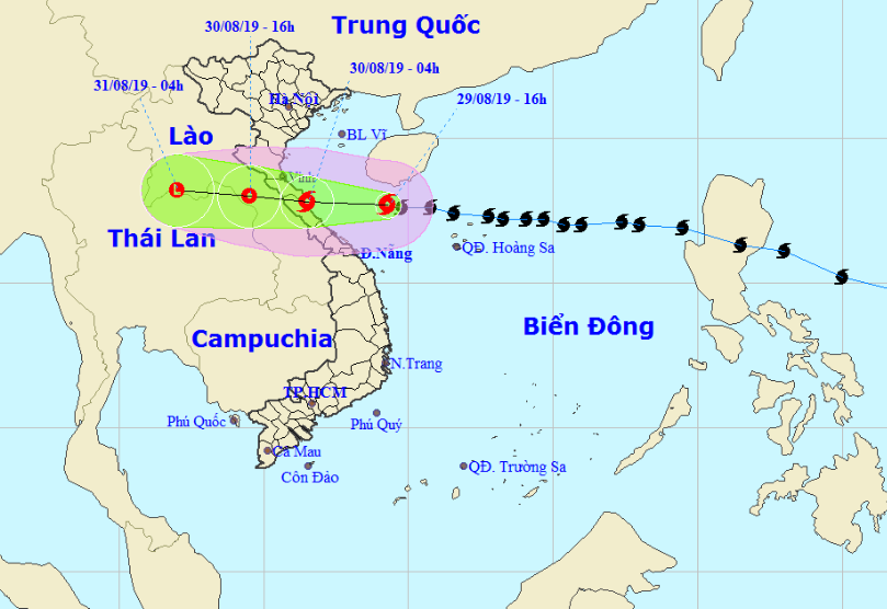 |
| The path of storm No. 4 updated at 4 p.m. on August 29. Photo: North Central Hydrometeorological Station |
At 4:00 p.m. on August 29, the center of the storm is located at about 17.7 degrees North latitude; 109.3 degrees East longitude, right in the South of Hainan Island, about 300km east of the mainland of Nghe An-Quang Tri provinces. The strongest wind near the center of the storm is level 9 (75-90km/hour),level 11. Radius of strong winds level 6, gusting to level 8 or higher is about 120km from the center of the storm.
In the next 24 hours,The storm is moving westward at 20km per hour. From early morning to noon tomorrow (August 30), it will make landfall in the provinces from Nghe An to Quang Binh with strong winds of level 8-9, gusting to level 11, then weaken into a tropical depression. At 4:00 p.m. on August 30, the center of the tropical depression will be at about 18.0 degrees North latitude; 104.5 degrees East longitude, in the Central Laos region. The strongest wind near the center of the tropical depression will be at level 6-7 (40-60km/hour).level 9
Dangerous areas in the East Sea in the next 24 hours(strong wind level 6, gust level 8 or higher)): North of latitude 16.0 degrees North; West of longitude 111.5 degrees East
Over the next 24 to 36 hours,The tropical depression moved inland and weakened into a low pressure area.
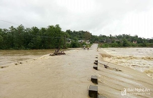 |
| Rain can cause major floods in mountainous districts. In the photo: Floodwaters overflowing the spillway in Thach Ngan commune caused local isolation in Con Cuong in July 2017. Photo courtesy |
*Warning of strong winds and big waves in the North Central region
+ At Sea:
From this evening and tonight (August 29), the sea from Thanh Hoa to Ha Tinh will have stronger winds of level 8 - level 9, gusting to level 11. Waves will be 2 - 4m high, near the storm center waves will be 3 - 5m high, very rough seas. The coastal areas of Thanh Hoa - Ha Tinh should be on guard against storm surges of 0.5 - 1.0m high.
+ On land:
Due to the direct impact of storm No. 4, from tonight (August 29), from Thanh Hoa to Ha Tinh, winds will gradually increase to level 6, then increase to level 7; areas near the storm's center will have strong winds of level 8 - level 9, gusting to level 11.
* Heavy rain warningin the North Central region:
From now until the morning of August 31, there will be moderate to heavy rain; In particular, in the South of Nghe An and Ha Tinh, there will be places with especially heavy rain and thunderstorms. The total rainfall in Thanh Hoa and the North of Nghe An is likely to reach 100 - 200mm; in the South of Nghe An and Ha Tinh, it is likely to reach 150 - 300mm, in some places over 400mm.
Thunderstorms are likely to produce tornadoes, lightning, hail and strong winds.
*Flood warning, flash floods, landslides, inundation:High risk of flash floods and landslides in mountainous areas: Muong Lat, Quan Son, Quan Hoa (Thanh Hoa); Ky Son, Tuong Duong, Con Cuong, Que Phong, Quy Chau, Quy Hop, Anh Son, Thanh Chuong (Nghe An); Huong Son, Huong Khe, Vu Quang, Ky Anh, Duc Tho (Ha Tinh).
- Risk of flooding in low-lying areas, urban flooding, especially Vinh city (Nghe An), Ha Tinh city (Ha Tinh), coastal plains of provinces from Thanh Hoa to Ha Tinh.
Storm disaster risk level: Level 3.


