Tropical depression may strengthen into storm, moving in the Northwest direction
(Baonghean.vn) - Due to the influence of a tropical depression that is likely to strengthen into a storm, there will be heavy thunderstorms in the central East Sea; strong winds of level 6-7, later increasing to level 8, gusting to level 10; very rough seas.
At 1:00 a.m. on June 3, the center of the tropical depression is located at about 13.0 degrees North latitude; 112.2 degrees East longitude, about 410km south of Hoang Sa archipelago. The strongest wind near the center of the tropical depression is level 6-7 (40-60km/hour),level 9.
Forecast for the next 24 hours, the tropical depression is moving in the North-Northwest direction, traveling about 10km per hour and is likely to strengthen into a storm. At 1:00 a.m. on June 4, the center of the storm was at about 15.1 degrees North latitude; 111.2 degrees East longitude, about 200km southwest of Hoang Sa archipelago, about 250km east of the coast of Quang Nam and Quang Ngai. The strongest wind near the center of the storm is level 8 (60-75km/hour).level 10. The range of strong winds of level 6, gusting to level 8 or higher is about 80km from the center of the storm.
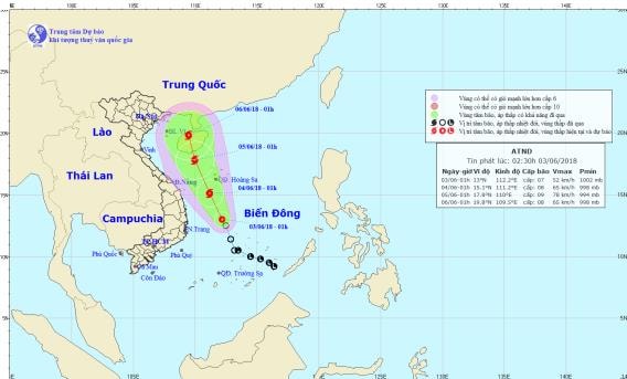 |
| Path and location of the tropical depression. Photo: National Center for Hydro-Meteorological Forecasting |
Due to the influence of the tropical depression that is likely to strengthen into a storm, there will be strong thunderstorms in the Central East Sea; strong winds of level 6-7, later increasing to level 8.level 10; very rough seas. The seas off the Central and Southern coasts, the seas from Ca Mau to Kien Giang and the Gulf of Thailand have showers and thunderstorms with tornadoes and strong gusts of wind.
Dangerous areas in the East Sea in the next 24 hours: (strong wind level 6 or higher) from latitude 11.0 to 17.0 degrees North; west of longitude 113.0 degrees East.Disaster risk level: level 3.
In the next 24 to 48 hours, the storm is moving in a northwest direction, traveling about 15km per hour and is likely to strengthen. At 01:00 on June 5, the center of the storm was at about 17.8 degrees North latitude, 110.0 degrees East longitude, right on the sea south of Hainan Island. The strongest wind near the center of the storm is level 8-9 (60-90km/hour).level 11. The range of strong winds of level 6, gusting to level 8 or higher is about 120km from the center of the storm.Disaster risk level: level 3.
In the next 48 to 72 hoursThe storm continues to move north at about 10km per hour.
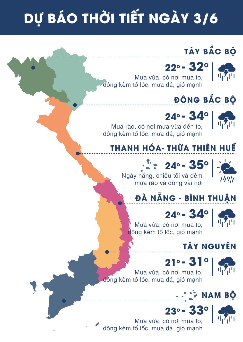 |
| Temperature on June 3, 2018 in regions across the country. Source: Zing.vn |
WARNING:
- Currently, water levels on rivers in the area from Quang Ngai to Binh Thuan provinces and the Central Highlands region have small fluctuations.
In the next 1-2 days, the coastal provinces of South Central Vietnam and the Central Highlands will have rain, moderate rain, and heavy rain in some places. Due to heavy rain, in the next 1-2 days, on the rivers from Quang Ngai to Binh Thuan and the Central Highlands, there is a possibility of a flood, with a flood amplitude of 1-3m.
Risk of flash floods on small rivers and streams, landslides in mountainous areas from Quang Ngai to Binh Thuan and the Central Highlands, especially in provinces such as: Quang Ngai, Khanh Hoa, Binh Thuan, Ninh Thuan. Disaster risk warning level: Level 1.
-Due to the influence of the low pressure trough analyzed above combined with the strong southwest monsoon in the South, in the next 1-2 days in the coastal provinces of South Central, Central Highlands and the South, there will continue to be rain, moderate rain, heavy rain in some places and scattered thunderstorms. During thunderstorms, be on guard against tornadoes, whirlwinds and strong gusts of wind.Disaster risk level: level 1.


.png "Nghệ An chủ động ứng phó áp thấp có khả năng mạnh lên thành áp thấp nhiệt đới, mưa lớn, nguy cơ lũ quét, sạt lở đất")