Need to clarify the irregularities in the compensation and site clearance records of the Quan Bau resettlement project
(Baonghean) - In the work of inventorying compensation for site clearance for the resettlement project in Quan Bau ward (Vinh city), there appeared land allocation records issued by the People's Committee of Hung Dong commune without authority since 1995. From citizen petitions and actual investigation, it is found that with these records, relevant agencies of Vinh city need to strictly control to avoid unfortunate mistakes...
Nghe An Newspaper received a petition from Mr. Ngo Quoc Tuan (residing in Block 7, Quan Bau Ward, Vinh City) with the following content: Mr. Tuan is the owner of land plot No. 01, map sheet No. 6, area 1,787.2m2; originally agricultural land granted by Hung Dong II Agricultural Cooperative to Mr. Ngo Xuan Chau and Ms. Nguyen Thi Mien (Mr. Tuan's parents) in the 1980s.
After Mr. Ngo Xuan Chau passed away, this land was assigned to Mr. Tuan for management and use. On October 6, 2005, Hung Dong II Agricultural Cooperative issued a land use right certificate to Mr. Tuan. During the use, Mr. Tuan renovated the land, dug a pond for aquaculture, built livestock barns to develop the household economy according to the VAC model.
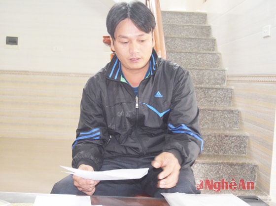 |
| Mr. Ngo Quoc Tuan presented the unreasonable things in handling the petition of the People's Committee of Quan Bau ward. |
In 2014, when the Quan Bau Ward Resettlement Project was implemented, because the entire land was located in the planning area, the Vinh City Land Fund Development Center conducted an inventory and developed a plan for compensation and site clearance.
However, when compensation was carried out, it was only carried out on a total area of 1,367.2 square meters; the remaining 420 square meters were not compensated. Checking the records at the People's Committee of Quan Bau Ward, Mr. Tuan discovered that in his land plot, there were 3 households that were granted residential land with an area exactly equal to the area of land that he was not compensated for, which was 420 square meters. Regarding this incident, Mr. Tuan has submitted many petitions to Quan Bau Ward and Vinh City but has not received a specific response...
To prove the above content, in the file attached to the application, Mr. Tuan sent excerpts of 2 cadastral maps (copied from the People's Committee of Quan Bau Ward) showing land plot No. 01. Of which, one map shows intact land plot No. 01 with an area of 1,787.2m2; the other map, also land plot No. 01 but on it appear 3 urban land lots with an area of 140m2/lot. Mr. Tuan affirmed that the location of the 3 land lots there is the pond area that he renovated for aquaculture. In many years, he has never heard of the Hung Dong commune government granting land to anyone; and there is no story of the people named in the 3 sets of documents loitering in this area...
Mr. Ngo Quoc Tuan said: “For the past year, I have sent a petition to the ward and the city but have not received any response. Recently, on November 12, 2015, the City People's Committee directed the Department of Natural Resources and Environment to verify, but I have not received a response document according to regulations. On December 25, 2015, the ward organized a meeting with me, but the petition issues have not been clarified. Surprisingly, on December 27, they implemented construction protection and site clearance. What is the reason for that?”
Following the information provided by Mr. Ngo Quoc Tuan, we determined that the People's Committee of Hung Dong commune granted 3 plots of land on plot 01 to Mr. and Mrs. Nguyen Dinh S, Le Van B, and Le Huy A (also in Vinh city) in 1995. In the records of those 3 plots of land, in addition to the application for "family residential land", there is a diagram of the location and area of the land plots confirmed by the hamlet executive committee and the People's Committee of Hung Dong commune; a receipt for "fees and charges"; and a receipt for the profits on the land. In the application for "family residential land", the land applicant pledged that "we are allocated land for housing, we will build according to the planning and fully comply with the regulations". As for the receipt for "fees and charges", the reason is stated as: "building the homeland"; besides, it also clearly states the origin as transferred personal residential land.
Working with the People's Committee of Quan Bau Ward, the leader of this ward affirmed that Mr. Ngo Quoc Tuan's request had no basis for resolution. The reason, according to Mr. Ho Sy Dung - Chairman of the People's Committee of Quan Bau Ward, was because the original agricultural land allocation file of Mr. Tuan's parents showed signs of erasure, the area was not 1,787.2m2. Later (when Mr. Tuan's father passed away), the area of the allocation file shown on the file continuously changed with different figures; only in 2005 was it shown as 1,787.2m2. Therefore, Quan Bau Ward organized an inspection to verify those responsible and held a meeting with the residential group to clarify.
After verification, the Chairman of Hung Dong II Cooperative and related officials have guaranteed in writing that they confirmed in the contract book to Mr. Tuan based on their feelings and without any basis to ensure its legality. Meanwhile, the 3 households that were assigned land by the People's Committee of Hung Dong commune without their authority have complete land allocation records since 1995; there are receipts proving that they have paid all fees and charges... Mr. Ho Sy Dung said: "People in the area all know clearly about Mr. Ngo Quoc Tuan's land use. I am also a local, so I also know that the area used to be abandoned bomb craters. Mr. Tuan got married around 2000; it was not until 2001 that he moved there to produce and renovate the pond... While the 3 households were granted land by the People's Committee of Hung Dong commune since 1995, how can Mr. Tuan demand compensation?"
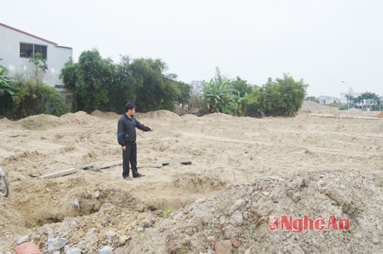 |
| The resettlement project area of Quan Bau ward, Vinh city has 3 land lots granted without authority that need to be clarified. |
Why is there a problem with Quan Bau ward managing cadastral maps with different information? According to Mr. Dung, Quan Bau ward was established in 2005, on the basis of merging a part of the land of Le Loi ward and Hung Dong commune. In 1994, Le Loi ward merged some land of Nghi Phu commune; in 2001, when making cadastral maps, due to the lack of standard land management, Le Loi ward measured and drew over the land of Hung Dong commune, including the land related to Mr. Ngo Quoc Tuan's petition.
Regarding the issue of Quan Bau ward checking the records of land allocation beyond the authority of Hung Dong Commune People's Committee for 3 households, Mr. Dung explained: Hung Dong Commune said that the accounting books showed that 3 households paid money to the commune-level state budget. Therefore, even if the land was granted beyond the authority, when the State recovered it, it still ensured the rights of the people. Raising the issue: According to Mr. Ngo Quoc Tuan, the location of the 3 plots of land is an aquaculture pond. He himself confirmed that the area was a bomb crater. So why did the fee and charge receipt of Hung Dong Commune People's Committee state that it was residential land transferred by an individual? Mr. Ho Sy Dung replied: "Regarding this, we also asked and the person involved in the land allocation in 1995 of Hung Dong Commune (still working) answered that only by stating it like that would the records be guaranteed for the City People's Committee to consider...".
In a discussion with the Department of Natural Resources and Environment of Vinh City, it was learned that in recent years, no application for Land Use Rights Certificates has been received from the 3 households related to Mr. Ngo Quoc Tuan's petition; however, the City Land Fund Development Center is currently inventorying assets and preparing compensation plans for these 3 households. With the information provided, the leader of the Department of Natural Resources and Environment affirmed that he would propose to temporarily suspend the implementation of the compensation plan to organize an inspection to clarify the matter.
Through investigation, it was found that there were many irregularities in the decision to grant land beyond the authority of the Hung Dong commune government to 3 households. For the 3 households, it is difficult to understand that since 1995, each household spent a large amount of money (from 7 to 8 million VND) to buy 140 square meters of abandoned pond in an area far from the center. In the application for "family land", all 3 households stated that they did not have land to live on.
So why have they not expressed their wish to be granted a Land Use Rights Certificate for housing construction for the past 20 years? As for the Hung Dong commune government, why did they provide incorrect information in the records related to land allocation? Is this fraudulent behavior just to “ensure the records” or are there other negative issues in the unauthorized land allocation?
These are things that the authorities need to clarify.
PV Group


