Storm No. 3 is forecast to weaken into a low pressure area, causing very heavy rain in Nghe An.
(Baonghean.vn) - In the past 3 hours, storm No. 3 has barely moved. At Bach Long Vi station, strong winds of level 7, gusting to level 8, have been observed. Due to the storm's impact, it is forecasted that this afternoon and evening, the North of Nghe An will have heavy to very heavy rain.
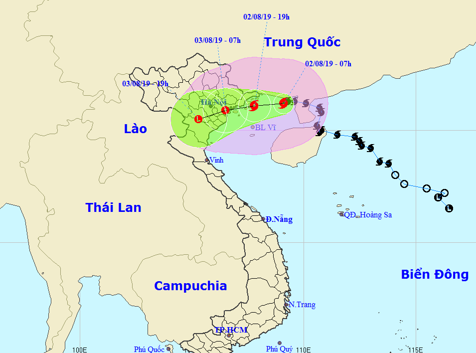
According to the latest information received from the North Central Hydrometeorological Station, at 7:00 a.m. on August 2, the center of the storm was at about 21.2 degrees North latitude; 109.1 degrees East longitude, about 180km east of the mainland of Quang Ninh-Hai Phong provinces. The strongest wind near the center of the storm was level 9 (75-90km/hour).level 12. Radius of strong wind level 6,level 8 jerkup to about 170km from the center of the storm.
 |
| Path of storm No. 3. Photo: North Central Hydrometeorological Station |
Forecast for the next 12 hours,The storm is moving westward at a speed of 5-10km per hour. At 7:00 p.m. on August 2, the center of the storm was at approximately 21.2 degrees North latitude; 107.8 degrees East longitude, right on the sea of Quang Ninh - Hai Phong. The strongest wind near the center of the storm is level 8-9 (60-90km/hour).level 12.
Over the next 12 to 24 hours,The storm is moving in the West Southwest direction, traveling 5-10km per hour, around tonight and tonight (August 2) it will make landfall in the provinces from Quang Ninh to Thai Binh with strong winds of level 7-8, gusting to level 10-11, then gradually weaken into a tropical depression. At 7:00 a.m. on August 3, the center of the tropical depression was at about 21.0 degrees North latitude; 106.5 degrees East longitude, on the mainland of the Northern midland delta provinces. The strongest wind near the center of the tropical depression is strong at level 6-7 (40-60km/hour).level 9.
Dangerous areas at sea in the next 24 hours(strong wind level 6, gust level 8): North of latitude 19.0 degrees North; West of longitude 111.0 degrees East.
Over the next 24 to 36 hours,The tropical depression moves mainly in the West Southwest direction, about 10km per hour, goes deep inland and weakens into a low pressure area.
*High Wind Warning:
+ At sea:
From today (August 2), in the sea areas of Thanh Hoa and Nghe An, the wind will gradually increase to level 6, then increase to level 7 - level 8, gusting to level 9, level 10. Waves are 2.0-4.0m high. The sea is very rough. The coastal areas of Thanh Hoa need to be on guard against storm surges combined with high tides of 3.0-4.0m.
 |
| Fishing boats of fishermen in Hoang Mai town anchored at fishing ports and creeks to take shelter from storm No. 3. Photo courtesy of Thanh Yen |
+ On land:
Due to the storm's influence, from this evening and tonight, in coastal districts of Thanh Hoa and northern Nghe An, there will be strong winds of level 4, sometimes level 5; then increasing to level 5-6, gusting to level 7 or above.
*ForecastHeavy rain in the North Central region:
In Thanh Hoa and the North of Nghe An province: Today (August 2), there will be rain, some places will have moderate rain. From the night of August 2 to the early morning of August 4, there will be heavy to very heavy rain, some places will have especially heavy rain and thunderstorms (total rainfall for the whole period is likely to reach 100 - 250mm, in Thanh Hoa alone, some places will have 300 - 400mm).
In the South of Nghe An and Ha Tinh provinces from today (August 2) to early morning of August 4, there will be rain, some places will have moderate rain and thunderstorms.
In cHeythunderstormshernahigh xheroutstainlstainc, sét, mUhaDahand the windyestmyesnh.
* Warning of floods, flash floods, landslides, and inundation in Thanh Hoa and Nghe An:
From August 3 to 6, there is a possibility of a flood in the upper reaches of Thanh Hoa and Nghe An rivers; with flood amplitudes in the upper reaches of Ma River, Buoi River (Thanh Hoa), Hieu River (Nghe An) and small rivers and streams ranging from 3.0 - 6.0m; downstream of main rivers ranging from 2.0 - 4.0m; other rivers fluctuating. Peak flood levels on Buoi River and upper reaches of Ma River (Thanh Hoa) are at level BĐ1 to BĐ2; downstream of Ma River is at level BDD1; and other rivers in Nghe An are below level BĐ1.
High risk of flash floods, floods due to blocked waterways, mudslides, landslides in mountainous areas, and flooding in low-lying areas in Thanh Hoa and Nghe An provinces.
Storm disaster risk level: Level 3

.jpg "Nghệ An: Lễ khai giảng đặc biệt ở xã biên giới bị thiệt hại nặng nề nhất sau bão số 3")


: cách Nghệ An khoảng 185km về phía Đông Đông Nam")
.jpg "Gần 5 tỷ đồng hỗ trợ học sinh Nghệ An bị ảnh hưởng bão số 3")
.jpg "Cán bộ Sở Nội vụ Nghệ An về xã miền núi hỗ trợ giải quyết kịp thời chế độ, chính sách cho cán bộ nghỉ việc")