Many bridges in Nghe An are flooded, traffic is disrupted.
(Baonghean.vn) - Due to heavy rain after storm No. 4, water levels in rivers and streams rose rapidly, causing many bridges in some districts in Nghe An to be deeply submerged in water, disrupting traffic.
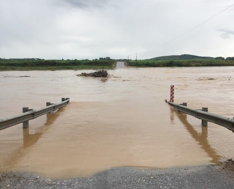 |
| Hieu spillway bridge in Nghia Hung commune, Nghia Dan district is deeply submerged in water and is closed to traffic. Photo: Van Truong |
As of 7:00 a.m. on August 31,National Highway 48E from Con Temple, Hoang Mai Town to Nghia Dan, Quy Hop currently has 4 flooded locations. Hieu spillway bridge, Nghia Hung Commune (Nghia Dan) section Km92+550, water is about 1.5 m deep, Dinh spillway bridge Km97+850 connecting Nghia Hung Commune, Nghia Dan District and Nghia Xuan Commune, Quy Hop District, water is over 1 m deep. There are 2 flooded locations where vehicles can still pass: Nghia Binh spillway, Nghia Dan at km59+950, Nghia Thinh spillway, Nghia Dan.
For the two large flooded bridges, Hieu and Dinh spillways, it is very dangerous for people and vehicles to pass through, so the management unit has set up fences and warning signs, and coordinated with local authorities to prevent people from crossing the spillways and being flooded. For shallow flooded bridges, vehicles can still pass through, the unit has assigned people to guard and be ready to close the spillways when the water rises.
According to the Provincial Steering Committee for Natural Disaster Prevention and Control: This morning, at Khe San spillway (Thanh Son commune, Anh Son district), the flood level is currently 1.9m; previously, the traffic management unit had closed the spillway at this location.
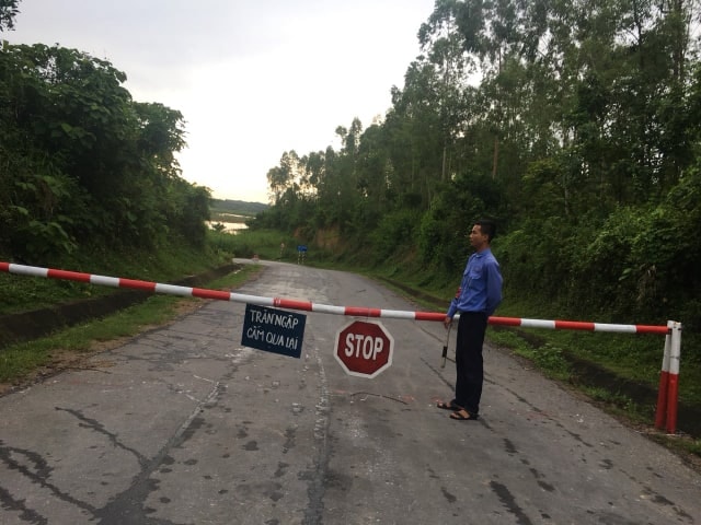 |
| 24/7 on duty at Hieu spillway barrier to prevent vehicles and people from passing. Photo: Van Truong |
Heavy rains caused many traffic routes to be eroded, such as Provincial Road 543C, with 10 landslides on the positive slope, filling up ditches and spilling over part of the road surface; Provincial Road 532 had 7 landslides.
In Quy Chau district, 3 spillways in Chau Phong commune were swept away by floodwaters, 19 small spillways were flooded, and traffic roads were eroded over 40 meters.
To ensure traffic safety during the flood season, the Department of Transport and local authorities of the districts directed relevant forces to conduct traffic diversion and assign guards on both sides, prohibiting traffic on many deeply flooded roads; Requesting traffic management units to mobilize machinery and vehicles to level landslides, ensuring traffic safety for people passing by.

Nghe An wants to build a flood map for the Ca River.
(Baonghean.vn) - In order to do a good job of warning about floods, flash floods, and landslides, thereby minimizing the damage caused by floods, Nghe An province wishes to be supported in building a flood map on the Ca River. That is the opinion of Mr. Nguyen Sy Hung - Deputy Director of the Department of Agriculture and Rural Development and Head of the Irrigation Sub-Department in charge of flood prevention and control in Nghe An, who recently discussed with Nghe An Newspaper in the program People ask, authorities answer.
Hydropower plant in Nghe An announced flood discharge after storm No. 4
(Baonghean.vn) - According to the Steering Committee for Natural Disaster Prevention and Control - Search and Rescue of Nghe An province, relevant units have announced the operation of flood discharge at Ban Ang Hydropower Reservoir (Xa Luong commune, Tuong Duong district) and Nam Mo Hydropower Reservoir (Ta Ca commune, Ky Son district).

.jpg "Bão số 10 áp sát, nhiều khu vực miền núi Nghệ An xảy ra sạt lở, chia cắt")

.jpg "Các phường tại Nghệ An sẵn sàng phương án di dời dân trước khi bão số 10 đổ bộ")


