LATEST NEWS ON STORM NO. 10: From September 28 to September 30, Nghe An province will have heavy to very heavy rain and thunderstorms.
According to the warning issued by Nghe An Hydrometeorological Station at 5:00 a.m. on September 28, storm No. 10 is moving very fast (nearly twice the average speed), has strong storm intensity, wide range of influence, and can cause combined impacts of many types of natural disasters such as strong winds, heavy rains, floods, flash floods, landslides and coastal flooding.
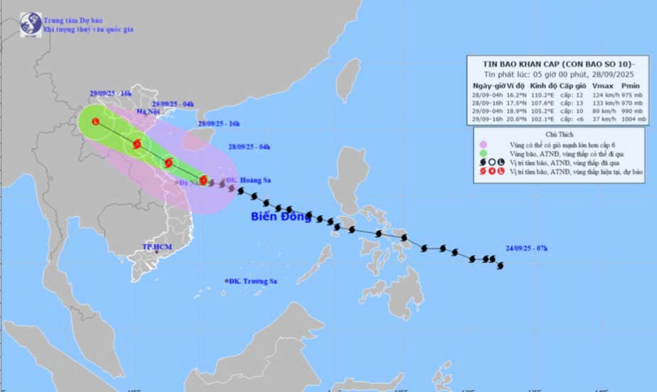
HOhi 04 giyeahngahSeptember 28, the center of the storm is located at about 16.2 degrees North latitude; 110.2 degrees East longitude, in the sea west of Hoang Sa special zone, about 200km east of Da Nang city. The strongest wind near the center of the storm is level 12 (118-133km/h), gusting to level 15. Moving in the West Northwest direction at a speed of 30km/h. This is a very fast moving storm (nearly twice the average speed), strong storm intensity, wide area of influence, can cause combined effects of many types of natural disasters such as strong winds, heavy rains, floods, flash floods, landslides and coastal flooding.
Dyesnewspaperến ballunmarketablenbão (t24basen 48 hoursyeahtohi):
| Thyeahi pointmdyesbaho | Directionng, tstaincdegree | Vpoopmind | Laughngdegree | Danger zonetom | Cincubationrincubatenatural disaster risk (Area)yesc chpoopuhernhenjoyng) |
| 4:00 p.m. September 28 | West Northwest, about 30km/h, likely to strengthen | 17.5-107.6E, on the sea of Nghe An-Quang Tri | Level 12-13, level 16 | Latitude 14.0N- 20.0N; West of longitude 113.0E | Cyesp 3: the western sea area of the North and Central East Sea (including Hoang Sa special zone); the sea area from Thanh Hoa to Quang Ngai |
| 4:00 a.m. September 29 | West Northwest, about 25-30km/h, going inland to the Central provinces | 18.9N- 105.2E, on the mainland of provinces from Thanh Hoa to Ha Tinh | Level 9-10, jerk level 13 | Latitude 15.0N- 20.0N; West of longitude 112.0E | Cyesp 4: coastal mainland area from Nghe An to northern Quang Tri Cyesp 3: the western sea area of the North and Central East Sea (including Hoang Sa special zone); the sea area from Thanh Hoa to Quang Ngai |
| 4:00 p.m. September 29 | West Northwest, 20-25km/h, moving inland and weakening into a tropical depression, then a low pressure area | 20.6N- 102.0E, in the Upper Laos area | < Level 6 | North of latitude 16.0N; West of longitude 106.5E | Cyesp 3: from Thanh Hoa to Quang Tri (including Hon Ngu island) and the North of Bac Bo Gulf (including Bach Long Vy special zone, Van Don, Co To, Cat Hai and Hon Dau island); Mainland area from Ninh Binh to Quang Tri |
Storm warning:
- The North and Central East Sea (including Hoang Sa special zone) has strong winds of level 8-9, the area near the storm's eye has winds of level 10-13, gusts of level 16, waves from 6.0-8.0m high, the area near the storm's eye has waves of 8.0-10.0m, and the sea is very rough.
- In the sea area of Nghe An (including Hon Ngu island), the wind gradually increases to level 6-7, gusts to level 8-9, waves 3.0 - 5.0m high, rough seas. From early morning on September 28, the wind increases to level 8-9, the area near the storm center passes through level 10-13, gusts to level 16, waves 5.0 - 7.0m high, rough seas (Scongestionc destroyyesicyesckinertialohn, wavetoncyesckinertiamstrongm marble shipton has trohng therilohn).
Waterc. Storm surge in coastal areas b.yeah:Coastal areas of Nghe An have storm surges of 1.5-2.0m high. There is a high risk of flooding along dykes, coastal roads, and river mouths due to storm surges and very high waves during the evening and night of September 28.
CherNotice:The weather at sea and in coastal areas during the storm is extremely dangerous and unsafe for any vehicle or structure operating in the danger zone such as: cruise ships, passenger ships, transport ships, cages, rafts, aquaculture areas, dykes, embankments, coastal routes. Vehicles are highly likely to capsize, be destroyed; be flooded due to strong winds, big waves and rising sea levels.
On the groundt liyesn:
From the afternoon of September 28, on the mainland in Nghe An province, the wind gradually increased to level 6-7, then increased to level 8-9, and near the storm center, level 10-12 (Scongestionc giohcohthto spilltree cstaini, house chuha, ca phonen, causeyesthyesiryestnyesng), level 14 jerk.
From September 28 to September 30, Nghe An province will have heavy to very heavy rain and thunderstorms. Forecasted rainfall: in the coastal plains and midlands: 150 - 300mm, some places over 450mm such as Hoang Mai, Truong Vinh, Nam Dan...; Mountainous areas: 150 - 250mm, some places over 350mm such as Que Phong, Quy Chau... Warning of risk of heavy rain (100mm/3h).
Thunderstorms may contain tornadoes, lightning, hail and strong winds.
.jpg "Bão số 10 áp sát, nhiều khu vực miền núi Nghệ An xảy ra sạt lở, chia cắt")
.jpg "Các phường tại Nghệ An sẵn sàng phương án di dời dân trước khi bão số 10 đổ bộ")
.jpg "Công ty Điện lực Nghệ An khẩn trương triển khai các phương án ứng phó bão số 10")

