Initial opinion on landslide at Xop Mat, Luong Minh commune, Tuong Duong district
(Baonghean.vn) -On May 17, the Institute of Geophysics (under the Vietnam Academy of Science and Technology) sent a delegation of scientists including Associate Professor, Dr. Cao Dinh Trieu, Dr. Le Van Dung, MSc. Mai Xuan Bach; Engineer Bui Anh Nam to Ban Xop Mat, Luong Minh commune to coordinate with scientists from Nghe An province and commune officials to survey landslide sites.
After field inspection and research, the Institute of Geophysics had some initial opinions on the landslide at Xop Mat as follows:
The entire Ban Xop Mat lies entirely within the landslide arc with the following structure (the values below are only measured by GPS so the accuracy is not high). The peak of the landslide arc is at an altitude of 235m above sea level, while the bottom of Nam Non stream is at an altitude of 65m. Thus, the height of the landslide arc is about 170m. There are clear signs of 3 terrain levels within the area of Ban Xop Mat: Low - average altitude 90m (±5m); Medium - average altitude 110 (±5m); High - average altitude 120m (±5m).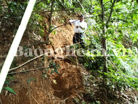
Geological surveyor in the field
Nam Non Stream is curved in the Ban Xop Mat area, in the shape of an arc. There is a phenomenon of an erosion channel flowing from an altitude of 235m to the lowest point of Ban Xop Mat. According to local people, this erosion channel appeared in June 2011, and also coincided with the phenomenon of the suspension bridge across Nam Non being bent. The soil and rocks on the surface within the landslide area were crushed, broken and were of the type that is easily permeable to water. This type of soil and rocks, when soaked in water, will turn into a slurry, with high rheological properties.
Initial assessment of the formation process of the Xop Mat landslide: This is a landslide that was formed a long time ago (possibly thousands of years ago). The main cause is strong tectonic activity in this area, specifically the activity of the fault running along the Nam Non stream. A sliding surface has been formed (the depth of the sliding surface has not been determined but is probably about 5-10m) which is the boundary between the hard rock layer below and the strongly broken rock layer above. The movement of this sliding mass has occurred slowly, but there are also sudden changes, thus creating the terrain steps as described above (see figure 1).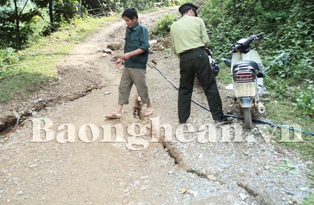
Survey at the crack point
When favorable conditions such as heavy rain, or the groundwater level is higher than the sliding surface, the sliding surface becomes more slippery, creating conditions for the rock mass above the sliding surface to move downwards. If there is a lot of rain, the rock mass on the surface becomes soft, under favorable conditions (high slope, no cover...) a mud and rock flood will appear (like June 24, 2011). The phenomenon of the suspension bridge over the stream being bent on June 24, 2011 is explained as follows: Heavy rain seeped into the sliding surface, causing the sliding surface to reduce friction and creating conditions for the sliding mass to move downwards. It is also possible that the stream water level rose higher (due to heavy rain and water discharge from the hydroelectric plant) than the sliding surface, making it more flexible and the sliding mass to operate. The entire Ban Xop Mat sliding mass moved downwards, exerting a large force along the bridge, the bridge pier on the committee side moved in the direction of reducing the length of the bridge and the bridge bent.
In that situation, the inspection team recommended that it is necessary to immediately relocate households located in the lowest part of the village (average elevation of 90m (±5m), where strong subsidence occurred in 2011) because they will be directly affected by the mud and rock flood that is likely to appear in the next rainy season. The entire village of Xop Mat is within the operating range of the active slide, so in the long term it is very dangerous, so it is recommended that there must be a plan for relocation in the coming time, if possible, as soon as possible. If possible, the entire village should be relocated without studying the structure of the slide. In case of relocating each section, it is recommended to conduct further research and surveys using geophysical methods and geological drilling. Specifically: using the method of electrical exploration (about 3 lines with a total length of 1.5 km with a cost of nearly 100 million VND); High precision gravity method (1.5 km line with a cost of about 100 million VND); Geological drilling to accurately determine the depth to the sliding surface (at least 2 boreholes, 15m deep, costing about 100 million VND. The total cost for geophysical survey and drilling is about 300 million VND. It is recommended to conduct research on the risk of cracks - subsidence, landslides and mudflows in the Ban Ve reservoir area.
Le Thanh


