5 new planning zones on both banks of the Vinh River
(Baonghean.vn) - According to the plan approved by the Provincial People's Committee, the spatial organization along the Vinh River has many new features. Accordingly, there are 5 planning zones that attract special attention from the people and investors.
The Vinh River is not a large river, flowing through the city of Vinh, but it plays a very important role for the city both historically and in the present.
Throughout the city's history, the Vinh River, along with the bustling Vinh Market and the majestic Dung Quyet Mountain, has contributed to making Vinh a vibrant and heroic urban center. Furthermore, the Vinh River serves as a vital transportation link, provides water for irrigation, and helps prevent natural disasters.
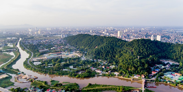 |
The Vinh River section flowing through Dung Quyet mountain. Photo: Thanh Cuong |
With the development of a first-class city and a focus on coastal development, Vinh City is expanding its urban transportation infrastructure, creating more open spaces, and the renovation and upgrading of the Vinh River has become a crucial task, contributing to making Vinh City greener, more beautiful, and more attractive, opening up more land resources and creating new investment opportunities for businesses.
The Prime Minister has officially approved the investment plan for the "Priority Infrastructure and Climate Change Adaptation Urban Development Project in Vinh City, Nghe An Province," comprising four components. Component 3 focuses on upgrading and renovating the Vinh River and public spaces. This is the first river project funded by the World Bank, with a total budget of US$178 million (equivalent to VND 4,450 billion). By June 2022, the People's Committee of Nghe An Province issued Decision No. 1525/QD approving the detailed construction plan at a scale of 1/500 for both banks of the Vinh River. This provides a crucial legal basis for protecting and implementing the Vinh River waterfront development plan as approved.
Shortly thereafter, the Vinh City People's Committee developed a detailed plan for both banks of the Vinh River, encompassing a portion of the planned land area in the following wards and communes: Vinh Tan, Trung Do, Hong Son, Cua Nam, Hung Chinh (Vinh City) and Hung Loi (Hung Nguyen District).
The planned area spans a total length of 7.3 km, starting at Duoc Bridge (Hung Chinh Ward, Vinh City) and ending at the confluence of the Vinh and Lam rivers. The width, measured from the center of the Vinh River outwards on each side, averages 100 meters, and will be further expanded in Cua Nam Ward, Vinh City. The total planned land area is 102 hectares.
According to the approved plan, the Vinh riverside area is planned.consists of 5 partsunew
These five zones, situated along both banks of the Vinh River, include: an ecological village zone, a heritage zone, a floating market zone, the Le Mao intersection zone, and a spiritual tourism zone. Each zone is designed with unique and distinct construction features, blending with the inherent identity of each location, promising to maximize tourism attraction, economic development, and the preservation of the river's cultural beauty.
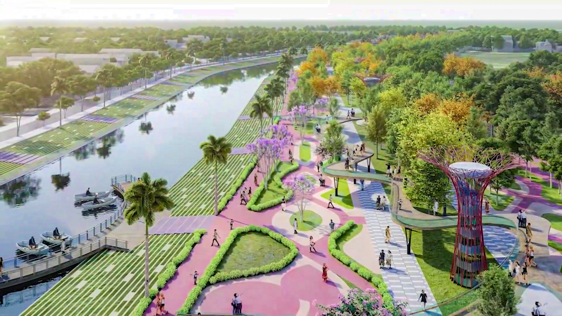 |
Perspective view of the pedestrian street and ecological park along the Vinh River. Photo: TC |
* Eco-village subdivision:Located between the Vinh River confluence and the railway bridge, this area is being developed into an agricultural park and eco-village with the following main components: Agricultural Park - a check-in point and a place for tourists to experience agricultural activities and explore the area; Flower Theme Park - featuring colorful seasonal flowers combined with contemporary art performances; Elevated pedestrian bridge - creating a walkway significantly higher than the ground, connecting the functional areas within the agricultural park; Kayak dock - a rest stop and kayak rental point.
Heritage ZoneLocation: From the railway bridge to the Cua Tien bridge. Creating a pedestrian walkway connecting the church, Cua Nam park, with the route ending at a small square and iconic building.
This area will be renovated around Cua Nam Lake, providing public services and additional amenities; transforming the riverside area in front of Cua Nam Park into a small park with floating platforms for access to the water; renovating the space on both sides of Cua Tien Bridge; and upgrading the existing residential area to meet the aesthetic and landscape requirements of the area. A pedestrian street combined with a night food street will be built along the river, improving accessibility to the riverbank.
* Floating market area:From Tien Gate Bridge to Cao Xuan Huy Bridge. This area capitalizes on its advantageous location next to Vinh Market - a market with a long history - to build a third stop with the aim of recreating the image of a floating market on the riverbank; constructing tourist service facilities and a glass (wooden) bridge for sightseeing.
Southern bank of the Vinh River: Construction of a wetland park, promenades, plazas, and wooden bridges accessing the riverbank. Riprap stone embankments will be used in this area.
* The fourth zone is the Le Mao intersection area:Running from Cao Xuan Huy Bridge to Den Bridge, this is a crucial intersection connecting the old and new sides of the city. According to the plan, it will serve as a rest stop for tourists to relax, enjoy the scenery, and sample and purchase local products, contributing to the dissemination of Vinh's culinary culture and traditions to domestic and international visitors. The northern bank of the Vinh River will feature a plaza, pedestrian walkways, and public amenities along the riverbank. The southern bank will include a wetland park, parking lots, promenades, plazas, and wooden bridges providing access to the riverbank.
The city is building a landmark bridge – the Le Mao Bridge – with a modern and eye-catching architectural style, similar to the Cua Tien Bridge.
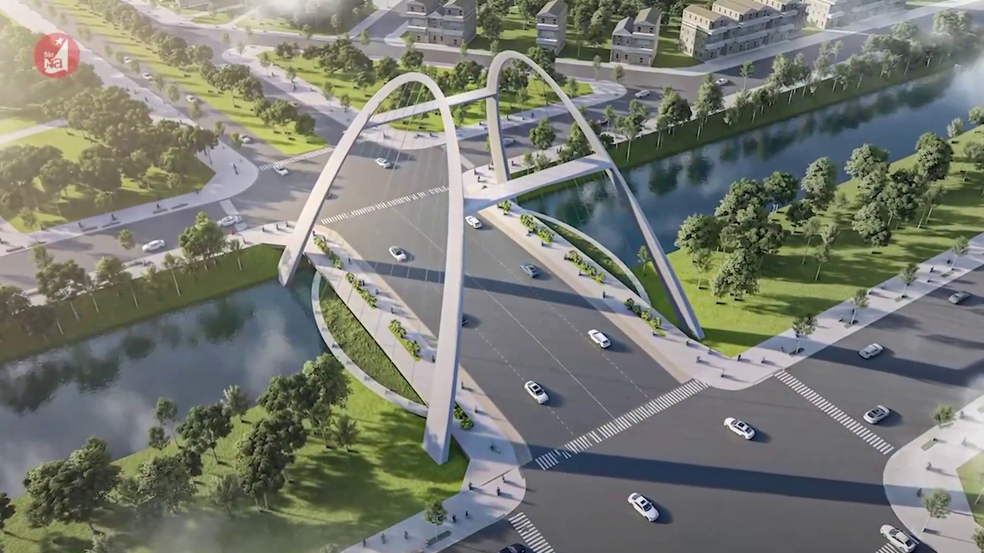 |
A striking feature – the Le Mao Bridge, with its modern and eye-catching architecture, is similar to the Cua Tien Bridge. Photo: TC |
* For the spiritual tourism area (sub-area 5):From Black Bridge to Ben Thuy Bridge, a spiritual tourism park is planned to be built on Quyet Mountain – home to the temple of Emperor Quang Trung, which was chosen by Emperor Quang Trung as the capital of Vietnam in the 17th century.
The plan aims to provide visitors with scenic views, unobstructed and panoramic vistas of the surrounding areas, and to make this one of the "must-visit" destinations when visiting Vinh City. On the southern bank, the water surface area will be renovated and expanded into a wetland park, with the construction of a square, park gate, and integrated amenities, while preserving the existing irrigation structures.
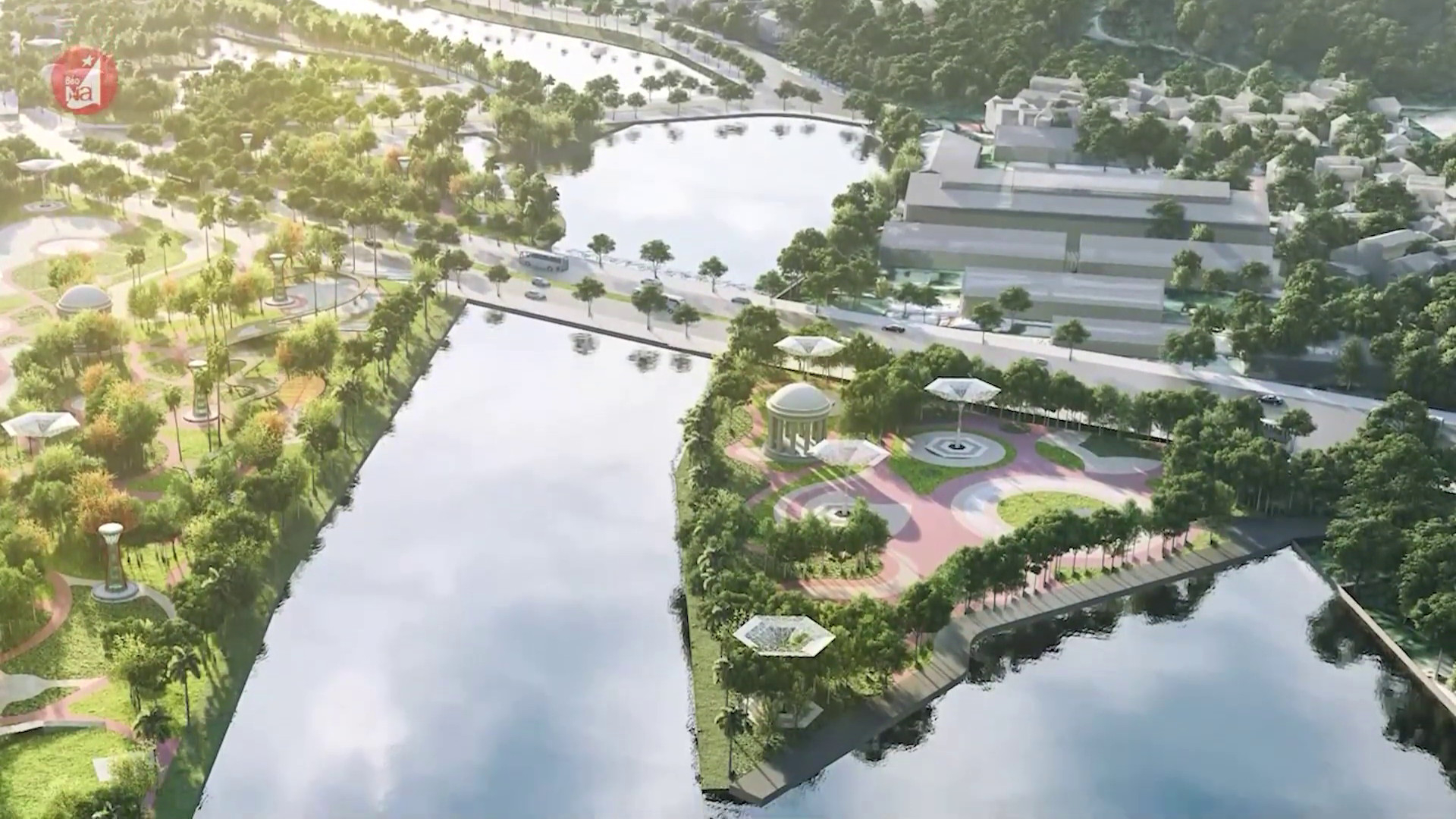 |
Perspective view of Zone 5 - Quyết Mountain spiritual tourism park. Photo: TC |
The Vinh River development plan includes 11 road bridges spanning the river, ranging in length from 38m to 45m; and one railway overpass with a length of 30m.
In addition to the five aforementioned zones, the plan also focuses on rainwater drainage and climate regulation.
For newly constructed areas along the river, land leveling will be carried out to ensure sufficient elevation for rainwater to drain naturally into the Vinh River. For existing residential areas, drainage follows two main directions. When the Vinh River water level is lower than the existing residential area's ground level, rainwater will naturally flow into the river through sluice gates and outlets. When the Vinh River water level rises above the existing ground level, rainwater cannot naturally drain into the river, and the sluice gates and outlets will be closed. The rainwater will then be transported to the pumping station and pumped into the river.
Currently, the city is implementing planning, protecting the plan, and selecting and attracting investment to ensure rational and efficient exploitation of land resources.

