Tropical depression strengthens into storm causing heavy rain in Nghe An
(Baonghean.vn) - This afternoon (June 12), the tropical depression in the southern area of Hainan Island (China) strengthened into a storm - storm number 2 in 2021 and has the international name KOGUMA.
According to the North Central Hydrometeorological Center, at 1 p.m., the eye of the storm was at about 18.8 degrees North latitude; 109.0 degrees East longitude. The strongest wind near the eye of the storm was level 8 (60-75 km/h), gusting to level 10. The radius of strong winds from level 6, gusting to level 8 or higher was about 120 km from the eye of the storm.
Forecast in the next 12 hours, the storm will move in the West Northwest direction, traveling 15-20km per hour, entering the Gulf of Tonkin. At 01:00 on June 13, the center of the storm will be at about 19.4 degrees North latitude; 107.2 degrees East longitude, right on the sea area from Hai Phong to Nghe An. The strongest wind in the area neareye of the stormlevel 8 strong (60-75km/h), level 10 jerk.
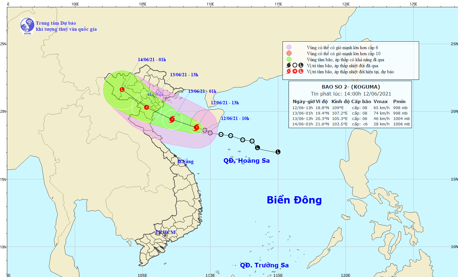 |
| The path of storm No. 2, internationally named KOGUMA. Photo: North Central Hydrometeorological Station. |
In the next 12 to 24 hours, the storm will move in the West Northwest direction, traveling 15-20km per hour, entering the mainland and directly affecting the provinces/cities in the Northeast and North Central regions, then weakening into a tropical depression. At 13:00 on June 13, the center of the tropical depression was at about 20.3 degrees North latitude; 105.3 degrees East longitude, right over the Southern region of the Northern Delta and Thanh Hoa. The strongest wind near the centertropical depressionlevel 6 strong (40-50km/h), level 8 gust. □
Dangerous areas in the East Sea in the next 24 hours (strong winds from level 6, gusts from level 8 or higher): North of latitude 17.5 degrees North; West of longitude 110.5 degrees East. All ships operating in the dangerous area are at high risk of being affected by strong winds and whirlwinds.
During the next 24 to 36 hours, the tropical depression will move in the West Northwest direction, about 15km per hour, go inland and then weaken into a low pressure area.
Disaster risk warning level: Level 3.
Weather in the North Central region:
Strong wind warning at sea: From this afternoon and night, June 12, in the North Central Coast, the wind will gradually increase to level 6-7, near the storm center it will be level 8, gusting to level 10, waves from 2.0-4.0m high; very rough seas.
Strong wind warning on land:From early morning and tomorrow (June 13), in Thanh Hoa and coastal districts in the North of Nghe An, the wind will gradually increase to level 6 - level 7; in the coastal areas of Thanh Hoa, some places will have level 8, gusting to level 9 - level 10.
Heavy rain warning:From now until June 13, in the provinces in the region, there will be moderate rain, heavy rain, locally very heavy rain and thunderstorms. During thunderstorms, there is a high risk of tornadoes, lightning, hail and strong gusts of wind. Rainfall is likely to reach 100 - 200mm/period, locally over 250mm/period.
Localized heavy rain in a short period of time poses a high risk of flash floods and landslides in the midlands and mountainous areas, and flooding in low-lying areas, cities and urban areas.
Disaster risk level due to tornado, lightning and hail: Level 1.


.png "Nghệ An chủ động ứng phó áp thấp có khả năng mạnh lên thành áp thấp nhiệt đới, mưa lớn, nguy cơ lũ quét, sạt lở đất")
