Update information on tropical depression near the East Sea
(Baonghean.vn) - According to the National Center for Hydro-Meteorological Forecasting, tonight and tomorrow (December 29), there will be thunderstorms and strong gusts of wind at level 6-7 in the South East Sea (including the waters of Truong Sa archipelago).
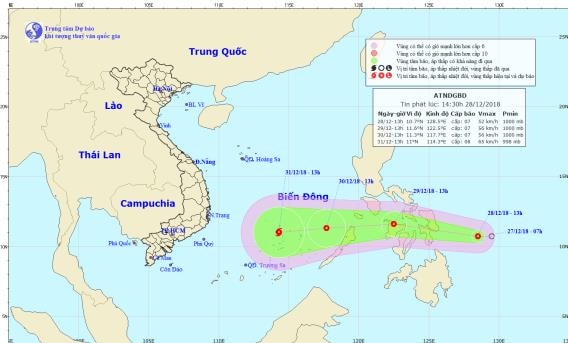 |
| The path and location of the tropical depression. Photo: National Center for Hydro-Meteorological Forecasting |
13:00 on December 28, the center of the tropical depression is located at about 10.7 degrees North latitude; 128.5 degrees East longitude, about 320km East Southeast of the central Philippines coast. The strongest wind near the center of the tropical depression is level 6-7 (40-60km/hour),level 9.
Forecast for the next 24 hours,The tropical depression is moving westward at a speed of about 20km per hour. At 1pm on December 29, the center of the tropical depression was at about 11.6 degrees North latitude; 122.5 degrees East longitude, in the central Philippines. The strongest wind near the center of the tropical depression is at level 7 (50-60km/hour).level 9
Over the next 24 to 48 hours,The tropical depression is moving westward at about 20km per hour, entering the East Sea. At 1pm on December 30, the center of the tropical depression was at about 11.3 degrees North latitude; 117.7 degrees East longitude, about 420km east of Song Tu Tay Island (Truong Sa archipelago). The strongest wind near the center of the tropical depression is level 7 (50-60km/hour).level 9.Disaster risk level: level 3.
During the next 48 to 72 hours,The tropical depression is moving west-southwest at 15km per hour and is likely to strengthen into a storm. At 7am on December 31, the storm center was located at approximately 11.0 degrees north latitude; 114.3 degrees east longitude, just south of Song Tu Tay Island (Truong Sa archipelago). The strongest wind near the storm center is level 8 (60-75km/hour).level 10.Disaster risk level: level 3.
Warning of thunderstorms and strong winds at sea: Tonight and tomorrow (December 29), in the South East Sea area (including the waters of Truong Sa archipelago), there will be thunderstorms and strong gusts of wind at level 6-7.
Due to the influence of cold air, in the Gulf of Tonkin and the North East Sea (including the waters of Hoang Sa archipelago), the Northeast wind will gradually increase to level 6-7, gusting to level 8-9; the sea will be rough and likely to last for the next 5-7 days.
From December 29, in the sea off the Central and Southern regions, there will be strong northeast winds of level 6, gusting to level 8; rough seas; in the central East Sea from around the night of December 29, due to the influence of strong cold air with a tropical depression that is likely to strengthen into a storm, the wind will gradually increase to level 7, and the area near the storm's center will increase to level 8.level 10. Rough seas.


.png "Nghệ An chủ động ứng phó áp thấp có khả năng mạnh lên thành áp thấp nhiệt đới, mưa lớn, nguy cơ lũ quét, sạt lở đất")
