'Up to Cau Ram Bridge, down to Ben Thuy Wharf'
(Baonghean.vn) - In Vinh, there is a proverb that almost everyone knows: "Up to Cau Ram Bridge, down to Ben Thuy Wharf".
"The 'Rumble Bridge' here is..."Cau Ram ChurchThe church and parish are named Cau Ram because not far from the church there is a bridge called "Ram". This bridge spans the drainage canal from Nghe An city to the Vinh River, now located in the Cua Nam overpass area.(1)As for why this bridge is called "Ram," no one has been able to explain it yet.
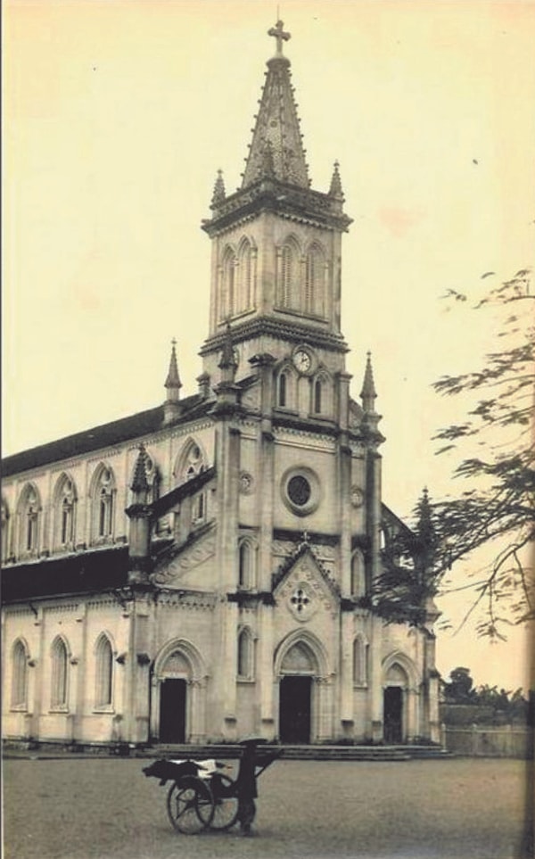 |
| Cau Ram Church was built in 1926. (Archival photo) |
It is no coincidence that Cau Ram Church has become such an iconic name and landmark of Vinh that it has even entered into idioms. Since the city of Vinh began to develop, Cau Ram Church has been famous as the largest and most beautiful church in the region. Cau Ram Parish was established in 1888, but before that, there was already a chapel here. Ten years later (1898), the parish church was built. It was a large building made of ironwood, consisting of seven bays, with fourteen Stations of the Cross on either side depicting the Passion and Death of Jesus Christ. In addition, there were eight other buildings within the parish grounds. Twenty years later, in 1918, the Parish Pastoral Council decided to sell the wooden church. In 1926, construction began on the magnificent and imposing Cau Ram Church, built in the Gothic style as it is known today. Cau Ram Church was inaugurated on July 20, 1928, and was considered the most beautiful church in Central Vietnam at that time.
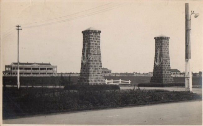
"Upstream at Cau Ram" is like that, but what about "Lower at Ben Thuy"?Ben ThuyOriginally just a ferry crossing the Lam River, connecting Vinh with Ha Tinh, Ben Thuy truly transformed after the French occupation of Nghe An in 1885. Immediately afterward, a wave of French and other investors poured into Ben Thuy. Wood factories, match factories, canning factories, power plants, and ports were built. Ferry services flourished. Hand-rowed ferries were already operating in 1899. The 1925 Vinh-Ben Thuy map only labeled it as "ferry" (bac), but the 1936 map indicated it as an engine-powered ferry (bac à moteur).
Until the end of the 19th century, Vinh was still only connected to Ben Thuy by the Vinh River, or by small, winding local roads.
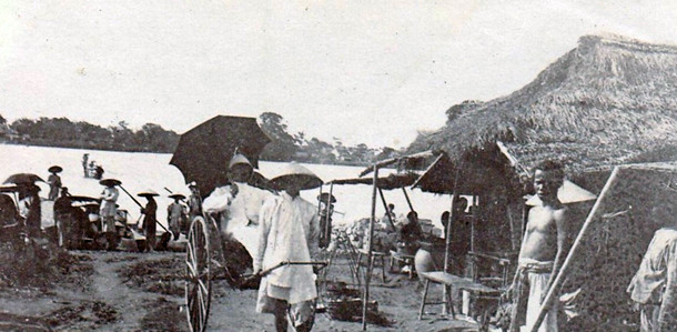 |
| Ben Thuy ferry terminal in the early 20th century. Archival photo. |
In 1890, businessman Jean Dupuis was granted 53,000 square meters of land in Ben Thuy, at the foot of Quyet Mountain, by the Governor of Nghe An Province, Dao Tan, to build a sawmill and a match factory. During construction, they built a 170-meter-long road, dug drainage ditches around it, and laid stones and sand on the sidewalks. Mr. Dao Tan and the French Commissioner (Mr. Myre) were very interested in this road.(2)When the two men learned that Jean Dupuis's associate, Millot, had 15 years of experience building roads in Shanghai, they commissioned Jean Dupuis's company to renovate the Vinh-Ben Thuy road in the "European style." This company employed 150 laborers and 50 prisoners to build the road. Despite being renovated in the "European style," the Vinh-Ben Thuy road was still only 3 meters wide and paved with gravel.
When the Vinh - Ben Thuy road was completed, Governor-General Dao Tan asked Jean Dupuis and Millot to purchase a Japanese handcart imported to Hanoi, which the French called a "pousse-pousse". This was probably the first handcart in Vinh - Ben Thuy.
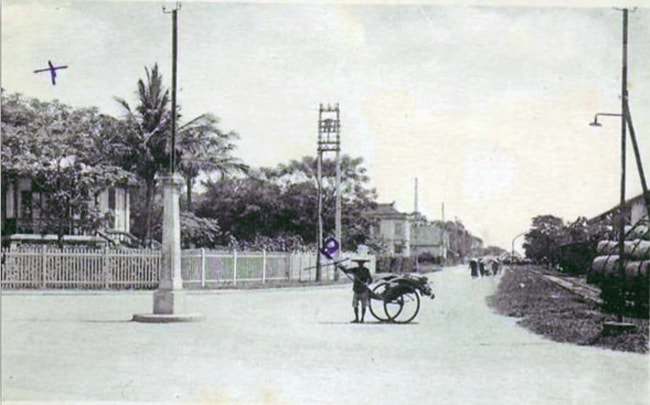 |
| Handcarts in Vinh - Ben Thuy. (Archival photo) |
1900(3)The French described it as follows: “When traveling from Ben Thuy to Vinh by road, on the right is the Camp des Lettrees, a collection of stone buildings where literary competitions were held. On our left is the Temple of Literature. The main road is about 3 meters wide, divided into two branches. One branch is on the right, about 5 km from Ben Thuy, connecting to the road from Thanh Hoa to Vinh; the second branch curves slightly to the left, going straight to Vinh and leading us to the Cau Ram area (Catholic church). The third road, this is the original road, which was destroyed by the military government. It is located north of the Temple of Literature, winding around the cluster of temples and pagodas shaded by trees in Yen Truong village and leading us to the ancient banyan tree, which is also the end point of the beautiful newly built boulevard running along the canal for about 1 km, leading us to the large market area and ending with a promenade planted with about 5,000 casuarina trees in front of the main building.” The Commissioner of Vinh. This forest is quite dense and promises to one day be the most beautiful area in Vinh city.(4)The road where 5,000 casuarina trees were planted is now Le Hong Son Street.
In the following years, the Vinh - Ben Thuy road was gradually built and expanded. By 1912, "from Ben Thuy to Vinh there was a very beautiful, wide and shady road."(5).
 |
| The Vinh Consulate, built in 1897, was located on the riverside, with its gate facing the old Cua Tien Bridge. This location is now Le Hong Son Street, Vinh City. (Archival photo) |
Few people know that, nestled alongside the paved road from Vinh to Ben Thuy, is a railway line, built in 1906 or 1907.The railway line starts from Vinh Station.It runs towards the end of what is now the BigC supermarket, then runs parallel to the road. At the Truong Thi Railway Factory, there is a branch leading there, while the main road continues down to Ben Thuy. At Ben Thuy is Ben Thuy Station, where trains receive goods from the port and industrial zone here, transporting them to Vinh Station and other destinations.
In the early decades of the 20th century, travel between Vinh and Ben Thuy was generally limited to walking, using rickshaws, or by boat along the Vinh River. By the 1930s, the Vinh-Ben Thuy road began to be paved with asphalt.
The article "Scenes at the Examination Hall" in the Thanh Nghe Tinh newspaper in 1935 described:
"Truong Thi is 3 km from Vinh, and used to be a desolate place. It only became bustling in the afternoons when thousands of workers from the large 'Atelier Truong Thi' factory came and went."
Since the former airfield was relocated to that plot of land, and several massive buildings, some two stories high, some three stories high, were constructed to serve as barracks for the French soldiers, the landscape of Truong Thi has changed.
 |
| Military camp at Truong Thi (currently the location of Military Region IV). Archival photo. |
The dilapidated, moldy houses scattered along the main road have been converted into coffee shops and general stores. In the afternoons, tourists stroll along Petain Road.(6)Walking down the street, the "sisters"(7)I spotted a few dance halls here and there…
The scenery was tranquil and cool, becoming more and more enjoyable the further we went… Then we reached Truong Thi, with its rows of factories and military barracks, and a straight, paved road leading down to Ben Thuy, 4 km from Vinh. Even here, it was very cool. Nestled against the Quyet mountain range with its natural rock formations and a naturally formed cave, the Match Factory overlooked two straight roads… In the twilight, several ships docked at the river. The beautiful buildings turned towards the docks.”
Over a hundred years have passed, and Vinh is no longer just "the area around Cau Ram Bridge and Ben Thuy Wharf," but has branched out in four directions. Even along this axis, the landscape has changed. But the old proverb still resonates...
 |
| Vinh City viewed from the Cua Nam fish pond. (Archival photo) |
_______________
(1) Cau Ram Parish Book 150 Years of Grace, Religious Publishing House 2018.
(2) Notes by Millot, associate of Jean Dupuis.
(3) Annuaire général de l'IndoChine française ["puis" de l'Indochine] 1900.
(4) Annuaire général de l'IndoChine française ["puis" de l'Indochine] 1900.
(5) Annuaire General de L'Indochine, 1912.
(6) Tran Phu Street today.
(7) Courtesan Street, at the end of Tran Phu Street today.
(8) Thanh Nghe Tinh Newspaper, No. 38, April 19, 1935.

