The low pressure area will strengthen into a low pressure area in the next 24 hours.
It is forecasted that in the next 24 hours, the low pressure area is likely to strengthen into a tropical depression, moving west towards the Gulf of Tonkin.
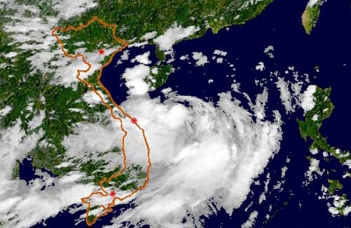
According to the National Center for Hydro-Meteorological Forecasting: At 1:00 p.m. on August 15, the center of the low pressure area was at about 21.7 degrees North latitude; 115.3 degrees East longitude, in the sea off the coast of Guangdong province (China).
It is forecasted that in the next 24 hours, this low pressure area is likely to strengthen into a tropical depression, moving west towards the Gulf of Tonkin.
 |
| Illustration photo |
Due to the influence of low pressure circulation combined with the activity of the tropical convergence zone, the northern waters of the Gulf of Tonkin and the northern East Sea (including the waters of the Hoang Sa archipelago) will have thunderstorms with tornadoes and strong gusts of wind. Disaster risk level 2-3.
From tomorrow evening and night (August 16), the Northeast region is likely to experience widespread heavy rain; from August 17, the heavy rain will expand to other areas in the North and North Central regions, and this rain is likely to last.
In addition, due to the influence of the strong southwest monsoon, the South China Sea (including the Truong Sa archipelago), the Binh Thuan-Ca Mau, Ca Mau-Kien Giang seas and the Gulf of Thailand continue to have thunderstorms with tornadoes.
The sea area from Binh Thuan to Ca Mau and the southern East Sea (including Truong Sa archipelago) has strong southwest winds of level 6-7, gusting to level 8-9, waves 2-4m high, rough seas. Disaster risk level: level 1./.
According to VOV
| RELATED NEWS |
|---|


.png "Nghệ An chủ động ứng phó áp thấp có khả năng mạnh lên thành áp thấp nhiệt đới, mưa lớn, nguy cơ lũ quét, sạt lở đất")
