Tropical depression appears in the East Sea
(Baonghean.vn) - Due to the influence of a tropical depression, the northeastern sea area of the North East Sea today and tonight (August 22) will have heavy thunderstorms; strong winds of level 6, gusting to level 7; rough seas.
According to the National Center for Hydro-Meteorological Forecasting,at 13:00 on August 22,The center of the tropical depression is located at about 22.3 degrees North latitude; 118.8 degrees East longitude, about 155km southwest of Taiwan. The strongest wind near the center of the tropical depression is level 6 (40-50km/hour),level 7. The range of strong winds of level 6, gusting to level 8 or higher is about 50km from the center of the tropical depression.
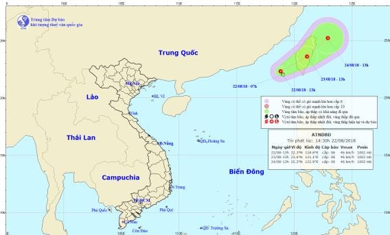 |
| The path and location of the tropical depression in the East Sea. Photo: National Center for Hydro-Meteorological Forecasting |
Forecast for the next 24 hours,The tropical depression is moving northeast, traveling about 5-10km per hour. At 1pm on August 23, the center of the tropical depression was at about 23.6 degrees north latitude; 121.1 degrees east longitude, right on Taiwan island. The range of strong winds of level 6, gusting to level 8 or higher is about 50km from the center of the tropical depression.
Due to the influence of a tropical depression, the northeastern sea area of the North East Sea today and tonight (August 22) will have heavy thunderstorms; strong winds of level 6, gusting to level 7; rough seas.
Over the next 24 to 48 hours,The tropical depression continues to move northeast, traveling 5-10km per hour.Disaster risk level due to tropical depression in the Northeast Sea of the East Sea: level 3.


.png "Nghệ An chủ động ứng phó áp thấp có khả năng mạnh lên thành áp thấp nhiệt đới, mưa lớn, nguy cơ lũ quét, sạt lở đất")
