Storm No. 3 with level 10 gusts is forecast to make landfall on the coast from Hai Phong to Ha Tinh tomorrow.
(Baonghean.vn) - Due to the impact of the storm, the coastal areas of the Northern Delta and North Central Coast are likely to have sea levels rise above the tidal range of 0.5-0.8m; waves 2-4m high; and rough seas.
Update the latest news of the National Center for Hydro-Meteorological Forecasting,At 4:00 p.m. today (July 17), the eye of the storm was at about 19.4 degrees North latitude; 114.7 degrees East longitude, about 400km east of Hainan Island. The strongest wind near the eye of the storm was level 8 (60-75km/hour).level 10.
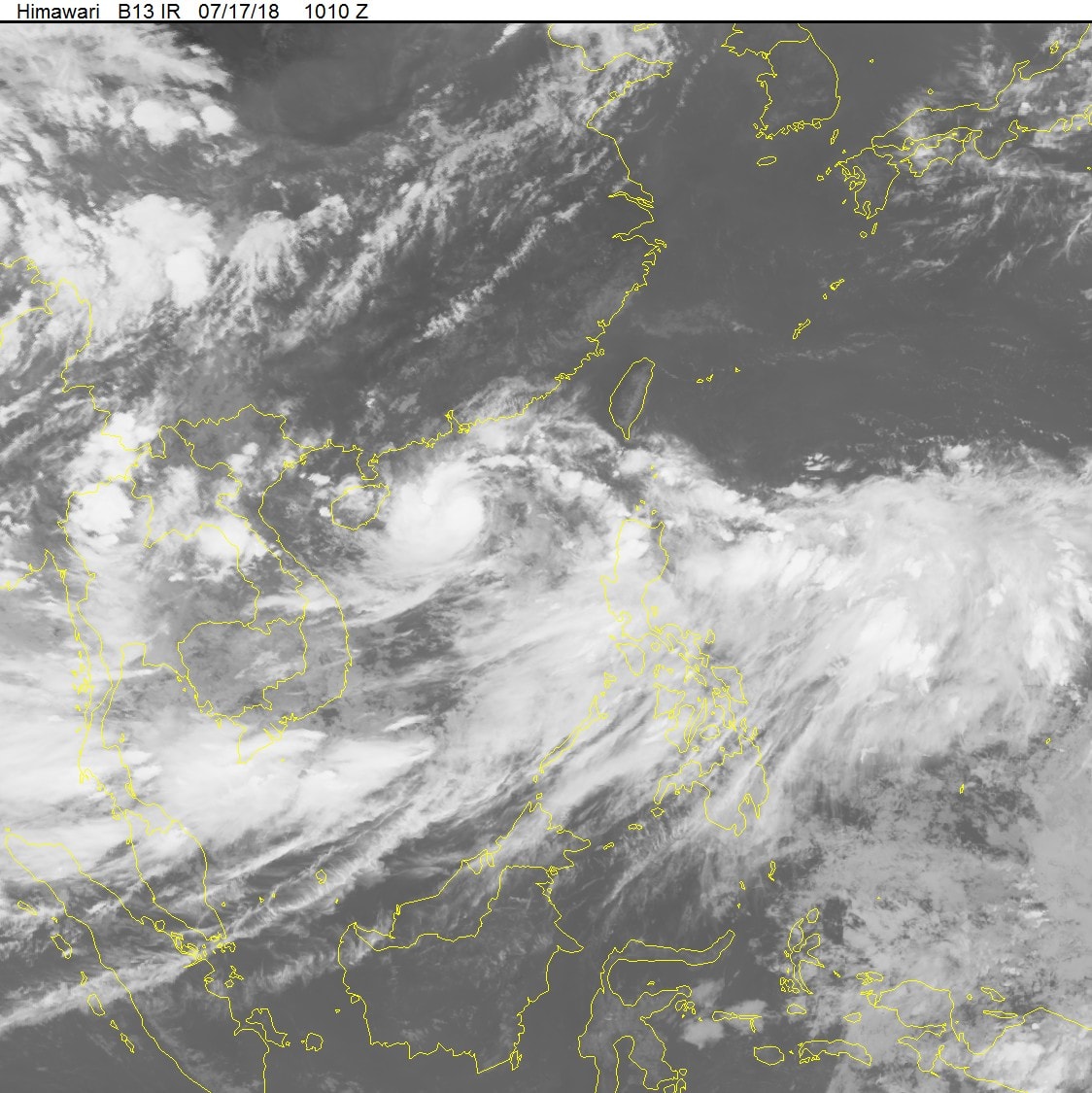 |
| Satellite cloud image. Photo: National Center for Hydro-Meteorological Forecasting |
Forecast for the next 24 hours, the storm is moving very quickly in the West direction, about 35km per hour, around tomorrow morning (July 18) storm number 3 will enter the Gulf of Tonkin. By 4:00 p.m. on July 18, the center of the storm is at about 19.5 degrees North latitude; 106.0 degrees East longitude, right on the coast of the provinces from Hai Phong to Ha Tinh. The strongest wind near the center of the storm is level 8 (60-75km/hour),level 10. The range of strong winds of level 6, gusting to level 8 or higher is about 100km from the center of the storm.
Due to the influence of the storm, in the North East Sea area (including the waters of Hoang Sa archipelago), there are heavy thunderstorms; strong storm winds of level 8,level 10; rough seas. In the Gulf of Tonkin from early morning and tomorrow (July 18), there will be strong winds of level 6-7, near the center of the storm will be strong winds of level 8, gusts of level 10, waves 4-6m high; rough seas. Coastal areas of the Northern Delta and North Central Coast are likely to see sea levels rise above the tide level of 0.5-0.8m; waves 2-4m high; rough seas.
Dangerous areas in the East Sea in the next 24 hours: (strong wind level 6 or higher) from latitude 17.5 to 21.5 degrees North.
Forecast for the next 24 to 36 hours, the storm continues to move rapidly to the West, traveling about 25-30km per hour;Around tomorrow afternoon and evening (July 18), the storm center will make landfall directly in the provinces from Hai Phong to Ha Tinh.then gradually weakened into a tropical depression. At 4:00 a.m. on July 19, the center of the tropical depression was at about 19.4 degrees North latitude; 103.0 degrees East longitude, in the Upper Laos region. The strongest wind near the center of the tropical depression was level 6 (40 - 50 km/h),level 7.
Forecast for the next 36 to 48 hours, the tropical depression continues to move rapidly to the West, weakening and gradually dissipating over the Upper Laos region.
Due to the storm's influence, from noon tomorrow (July 18), on land in the coastal provinces of the North and North Central regions, winds will gradually increase to level 6-7, and near the storm's eye, level 8.level 10From tomorrow noon, in the provinces of the Northern Delta and midlands, the provinces from Thanh Hoa to Quang Binh will have very heavy rain again and will last until about July 20 (commonly 100-300mm/period, some places over 350mm).Storm disaster risk level: level 3.
*In the face of the complicated developments of the storm, the Steering Committee for Natural Disaster Prevention and Control of Nghe An province issued Official Dispatch No. 06 (on the afternoon of July 17), directing localities and functional agencies to deploy effective prevention plans.
FLOOD DEVELOPMENT
1. Flood developments
Currently, the flood on Ngan Sau River (Ha Tinh) is rising, Ngan Pho River (Ha Tinh) is fluctuating at its peak. The water level at 4:00 p.m. on July 17 on Ngan Sau River at Chu Le was 10.38m, approximately level 1, at Hoa Duyet 7.04m, 0.46m below level 1; Ngan Pho River at Son Diem was 11.38m, approximately level 2.
2. Flood forecast
Flood on Ngan Sau River continues to rise, Ngan Pho River gradually recedes. In the next 12 hours, the water level on Ngan Sau River at Hoa Duyet will rise to 7.5m, at level BĐ1; Ngan Pho River at Son Diem will fall to 9.0m, 1.0m below BĐ1.
3. Warning
Due to the influence of the tropical convergence zone, tonight (July 17), in Hoa Binh, the Northern Delta region and provinces from Thanh Hoa to Quang Binh, there will continue to be moderate to heavy rain.
From tomorrow afternoon (July 18) to the night of July 19, due to the influence of storm No. 3, in the Northern Delta and midland areas, the provinces of Hoa Binh, Son La, Thanh Hoa, Nghe An, and Ha Tinh will have very heavy rain again.
From July 19-20, heavy rain is likely to spread to the northern mountainous provinces and the Northwestern region (very heavy rain is concentrated in Vinh Phuc, Phu Tho, Tuyen Quang, Yen Bai, Son La).
Flood warning:From July 18 to July 20, a flood will occur in the upper reaches of the Red River - Thai Binh River system, Hoang Long River, and rivers from Thanh Hoa to Ha Tinh. The flood peak on the Da River, Thao River, Hoang Long River, and the upper reaches of rivers in Thanh Hoa, Nghe An, and Ha Tinh will rise to level BĐ1-BĐ2, except for the Buoi River (Thanh Hoa) which will rise above level BĐ2; the lower reaches of the main rivers in Thanh Hoa, Nghe An, and Ha Tinh will be below level BĐ1.
Flash flood, landslide and flooding warning:There is a high risk of landslides and flash floods in mountainous areas of the northern provinces, especially the provinces of Hoa Binh, Son La, Lai Chau, Dien Bien, Lao Cai, Yen Bai, Tuyen Quang, Quang Ninh and the provinces from Thanh Hoa to Ha Tinh; flooding in low-lying areas and urban areas in the provinces of Hai Duong, Ha Nam, Nam Dinh, Ninh Binh, Thai Binh, Hoa Binh, Hanoi and from Thanh Hoa to Ha Tinh.(It is necessary to pay attention to detailed flash flood and landslide warning information to district level in flash flood and landslide warning bulletins).
Warning level of natural disaster risk due to floods, flash floods, landslides: level 2.


.png "Nghệ An chủ động ứng phó áp thấp có khả năng mạnh lên thành áp thấp nhiệt đới, mưa lớn, nguy cơ lũ quét, sạt lở đất")
