Need to clarify the delay in granting and exchanging land use right certificates for people in Quynh Luu district
(Baonghean.vn) - Nghe An Newspaper has just received a petition from Mr. To Ngoc Van, residing in Tuan A hamlet, Quynh Chau commune (Quynh Luu) about the "detention" of the application for changing the Land Use Rights Certificate for the land plot that he inherited from his mother.
When the file is "detained"
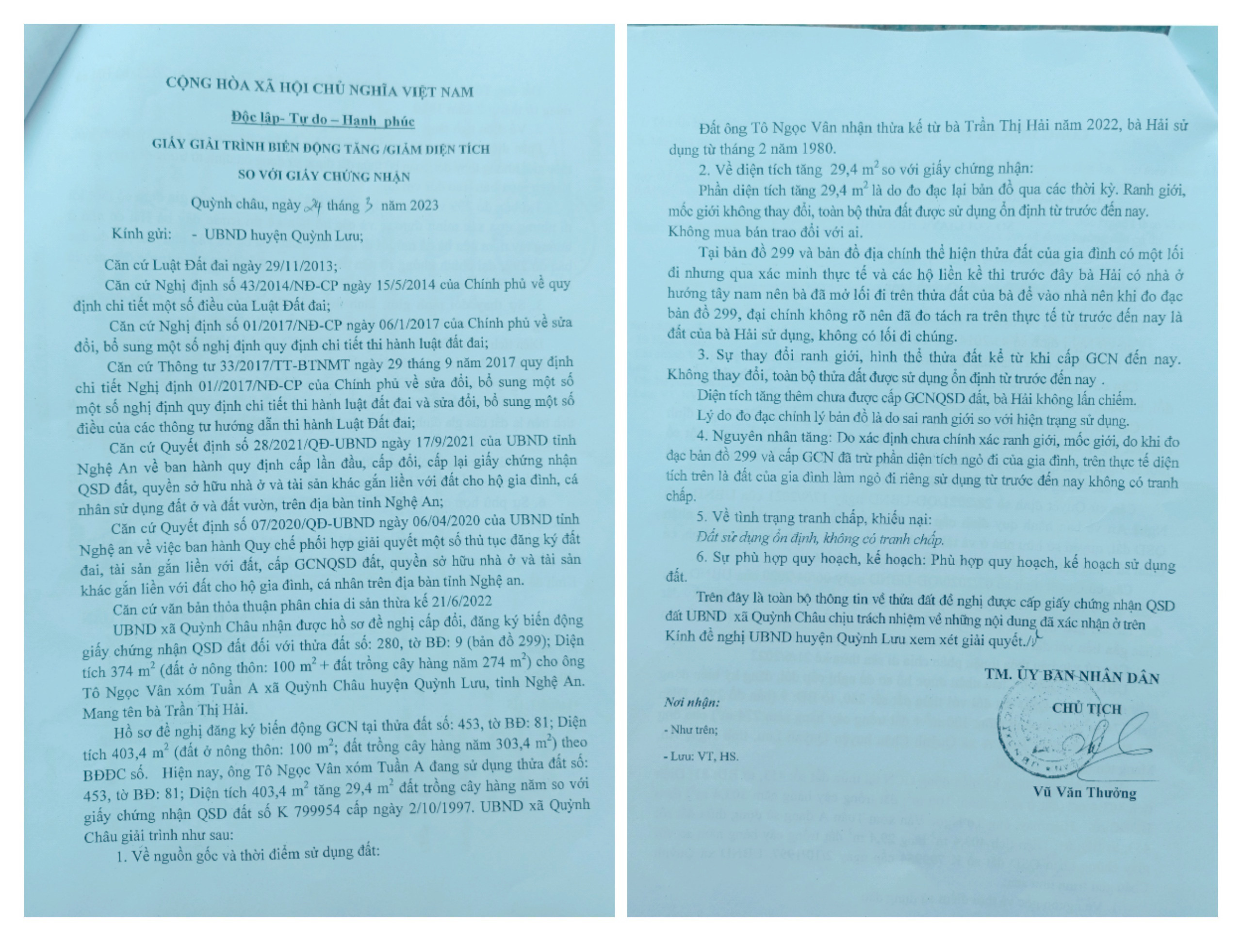
According to the presentation, Mr. Van inherited land plot number 453, map sheet 81 (2015 Cadastral map) in Tuan A hamlet,Quynh Chau commune, from his mother, Mrs. Tran Thi Hai, with an area of 403.4m22(According to the old Land Use Rights Certificate, it is 374m2)2).
After completing the inheritance procedures and extracting the land plot changes, on March 15, 2023, Mr. Van submitted the application for land use rights change to the one-stop department of the People's Committee of Quynh Luu district. After many times of editing and supplementing the application, Mr. Van completed the application and was scheduled to receive the results on May 22, 2023. However, up to now, Mr. Van has not yet received the Land Use Rights Certificate.
“On the appointed day, I went to receive the results and was told that they were not available yet. When I asked why, I was directed to meet one person after another. On June 19, 2023, I met an officer of the Department of Natural Resources and Environment of Quynh Luu district and was told that there was no time to review the file and that the officer left a phone number for contact. It continued like that until July 25, 2023, I received a file return slip and an apology from the Department of Natural Resources and Environment. The reason for returning the file was because my family's land area increased to 29.4m2. The Department of Natural Resources and Environment of Quynh Luu district said that on map 299 and the 1997 cadastral map, there is an entrance alley located in the southeast of the land plot, but the 2015 cadastral map no longer shows this alley. They said that 29.4m2That is the encroachment on the old road and must be administratively sanctioned according to the provisions of Article 14, Decree No. 91/2019/ND-CP dated November 19, 2019 of the Government, so the Land Use Rights Certificate was not issued to me" - Mr. Van said indignantly.
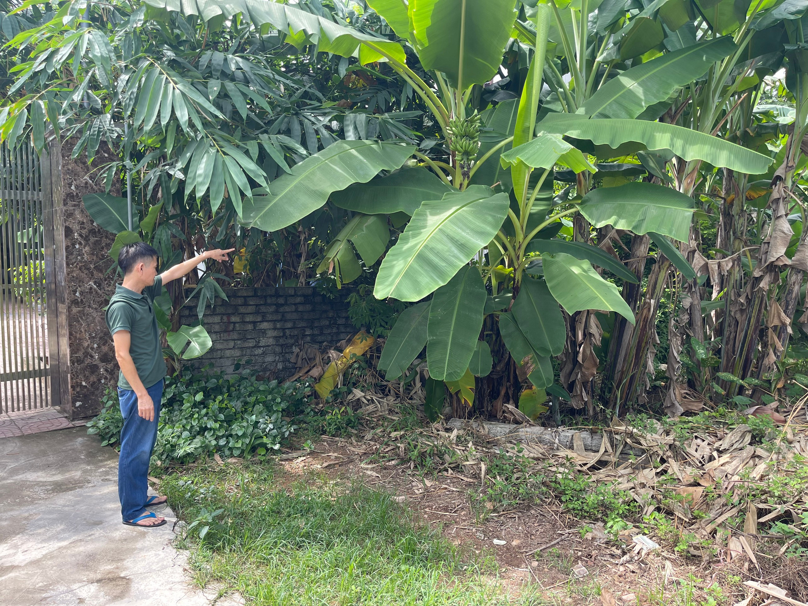
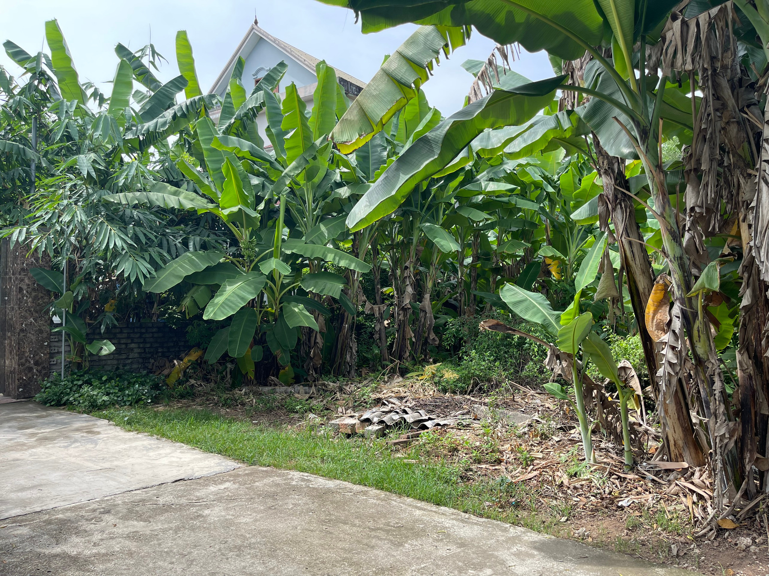
Studying the 299 map and the 1997 cadastral map (paper map), we noticed that there was a road drawn on the southeast side of the plot of land. However, according to Mr. Van, the plot of land was reclaimed by his parents in the 1980s, when the surrounding area was still wild land and no households had yet lived there. The reason there was a road on the southeast side of the plot of land was because before, Mr. Van's family's house faced the southwest (towards the field), so his parents opened a small path along the plot of land to enter the house. Later, because there was no need to use that path anymore, the family proactively demolished this small path to turn the house in another direction more conveniently. By 2015, when the digital map was re-measured, this road no longer existed.
According to our observations, the land that Mr. Van inherited is located about 100m from Highway 48, near the end of the dead-end road. Currently, the surrounding land has been built by neighboring families to separate fences, there is no longer any road located to the southeast of the land.
Mr. Van also said that if his family encroached on 29.4m2The traffic route is incorrect, because it is a private path that the family opened to match the previous house direction. And even, if the information on the previous land register is correct, the family's land is up to 1,072m2.2, that is, there is a shortage compared to the books, not a surplus of 29.4m.2so.
The commune said the land was family land, the district said no!
Mr. Vu Van The - Land officer of Quynh Chau commune said: On March 24, 2023, the People's Committee of Quynh Chau commune reported the increase/decrease in area compared to the certificate for the case of the land plot that Mr. Van inherited. Accordingly, the land use right certificate was previously under the name of Ms. Tran Thi Hai, with an area of 374m22(of which 100m2residential land and 274m2land for annual crops). Currently, after the 2015 digital map measurement, the area of the land plot is 403.4m2, increased by 29.4m2 Land for annual crop cultivation, compared with land use right certificate No. K 799954 issued on October 2, 1997 to Ms. Tran Thi Hai.
Also according to the explanatory report of the People's Committee of Quynh Chau commune, the area increased by 29.4m2is due to re-measurement of the map over time. The boundaries and landmarks have not changed, the entire plot of land has been used stably up to now, without any purchase or sale with anyone. On map 299 and the cadastral map, it is shown that the family's land has a path, but through actual verification and neighboring households, Ms. Hai previously had a house facing southwest, so she opened a path on her land to enter the house, so when measuring map 299, the cadastral map was not clear, so it was measured separately. In fact, up to now, the land has been used by Ms. Hai, there is no common path.
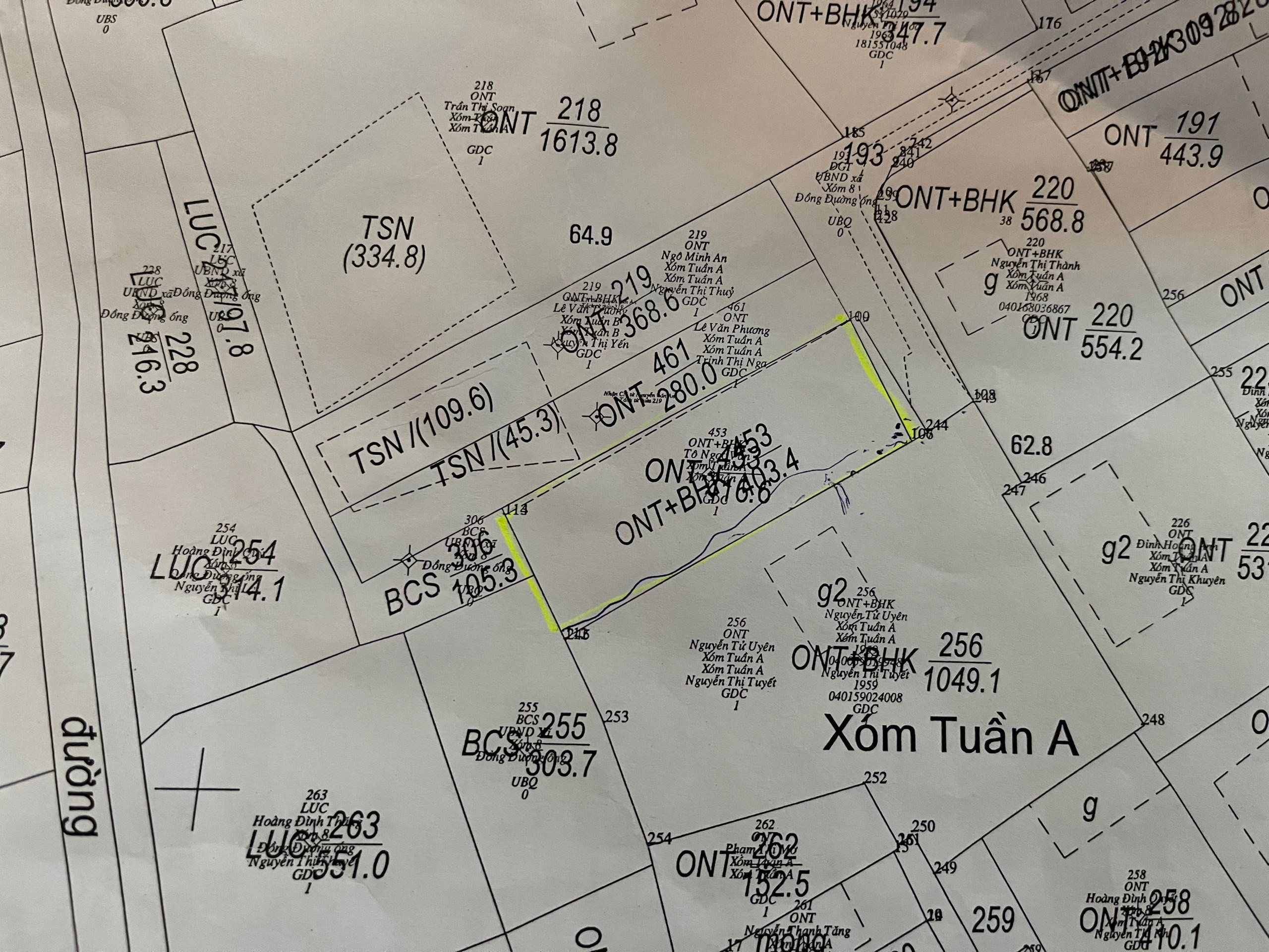
In addition, the shape of the land plot has not changed since the first land use right certificate was issued. The entire land plot has been used stably up to now. The People's Committee of Quynh Chau commune also affirmed that the increased area was not due to Ms. Hai's encroachment. And the reason for the increase is that during the process of measuring and adjusting the map, it was incorrect compared to the current usage status. When measuring map 299 and issuing the certificate, the family's alley area was deducted. In fact, the above area is the family's land used as a private alley and has been used without any dispute up to now.
Even in the verification report conducted by the Branch of the Land Registration Office of Quynh Luu District and the People's Committee of Quynh Chau Commune, when asking the opinion of the neighboring household, Ms. Nguyen Thi Tuyet, about the fact that there used to be a road to the Southeast of the land plot, but now it no longer exists. Ms. Tuyet also affirmed: "Previously, it was an alley leading to Ms. Tran Thi Hai's house, not a social traffic road. My family also had a time using her alley. Now my family does not use that alley, there is no dispute."
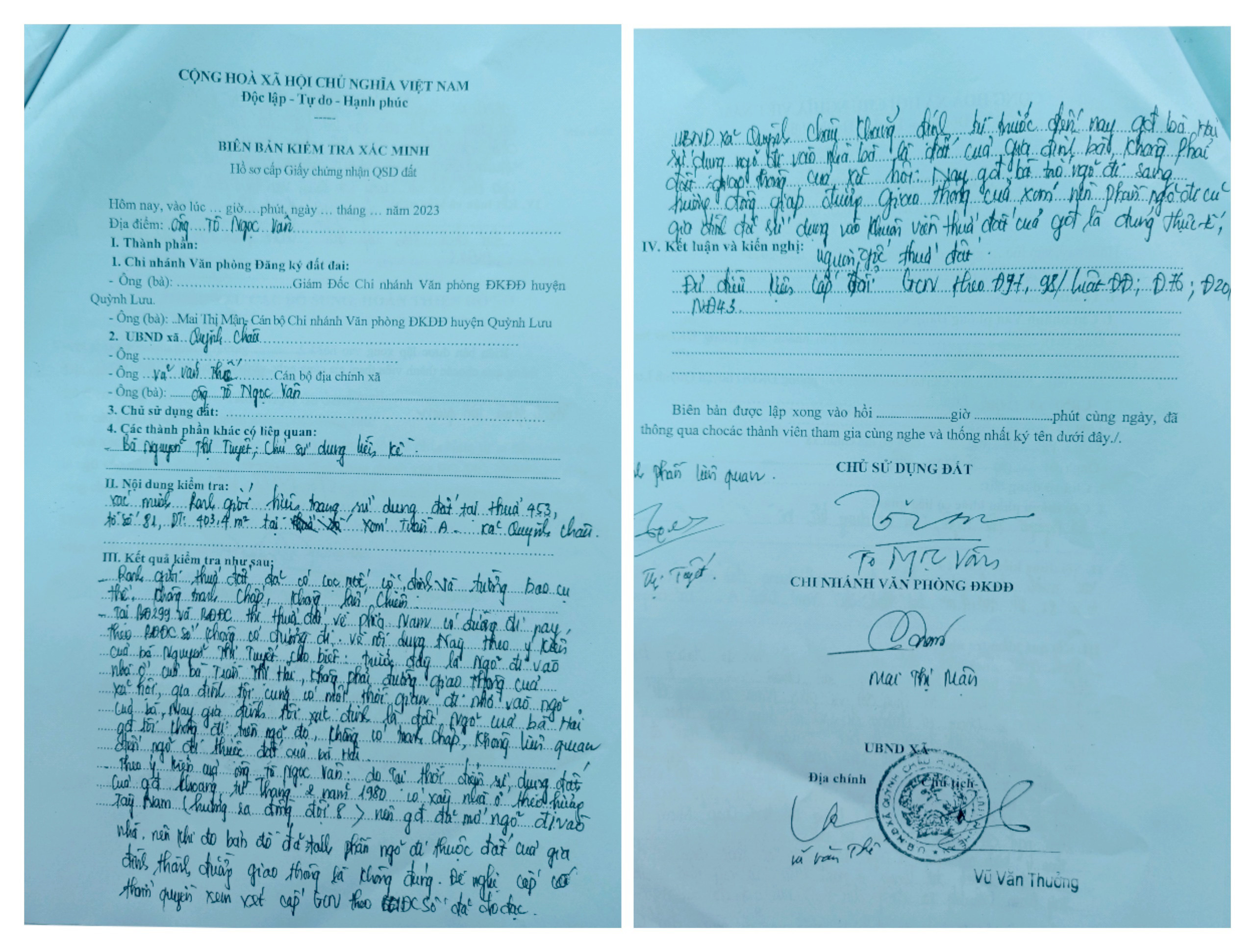
In this Inspection Report, the People's Committee of Quynh Chau Commune once again affirmed that the path that Ms. Hai's family used before was family land, not social traffic land. Now the family has turned the path to the East, adjacent to the traffic road of the hamlet, so the family has used the old path part of the path into the family's land plot.
Working with us, the leader of the Department of Natural Resources and Environment of Quynh Luu district continued to affirm that, based on map 299 and the 1997 cadastral map, there is a small road next to Mr. Van's family's land plot. During the land use process, the family added the land area as an alley located in the Southeast to the land plot, which is an act of encroachment according to the provisions of Article 14, Decree No. 91/2019/ND-CP dated November 19, 2019 of the Government on administrative sanctions in the field of land.
Mr. Nguyen Van Nhat - specialist of the Department of Natural Resources and Environment of Quynh Luu district, who received and processed the documents of Mr. Van's family, said that according to the provisions of Point d, Clause 1, Article 65 of the Law on Handling of Administrative Violations 2012, in this case, the violator, Ms. Hai, has passed away, so no decision on administrative penalty will be issued. However, the 29.4m2 land2In addition, the family must also fulfill its obligations to the State.
Mr. Nhat himself also admitted his mistake in processing the documents slower than the regulations, due to the large amount of work recently and having to focus on implementing site clearance for key projects...
Obviously, there is no consensus here between the local government - who directly grasp the reality at the grassroots level and the Department of Natural Resources and Environment of Quynh Luu district - the unit that advises on procedures for granting and exchanging Land Use Rights Certificates for the people. Even the errors of map 299 (possibly due to manual measurement) have not been taken into account. Therefore, this matter needs to be clarified to avoid affecting the rights of the people.


