Explaining the cause of Vinh City's unprecedented flooding
(Baonghean.vn) - It can be said that Vinh city has never experienced such a big flood as on October 16, 2019.
Because the terrain and location of Vinh city are very convenient for flood drainage and flood prevention, there have been concerns. Nghe An Newspaper looks for the cause to answer this question.
Ben Thuy pumping station stopped operating at 7am
Surveying Ben Thuy Pumping Station, people living in the vicinity confirmed that at noon on October 16, when the flood water was at its highest, the entire area, including the pumping station, was heavily flooded, with rainwater overflowing onto the road around the foot of Quyet Mountain.
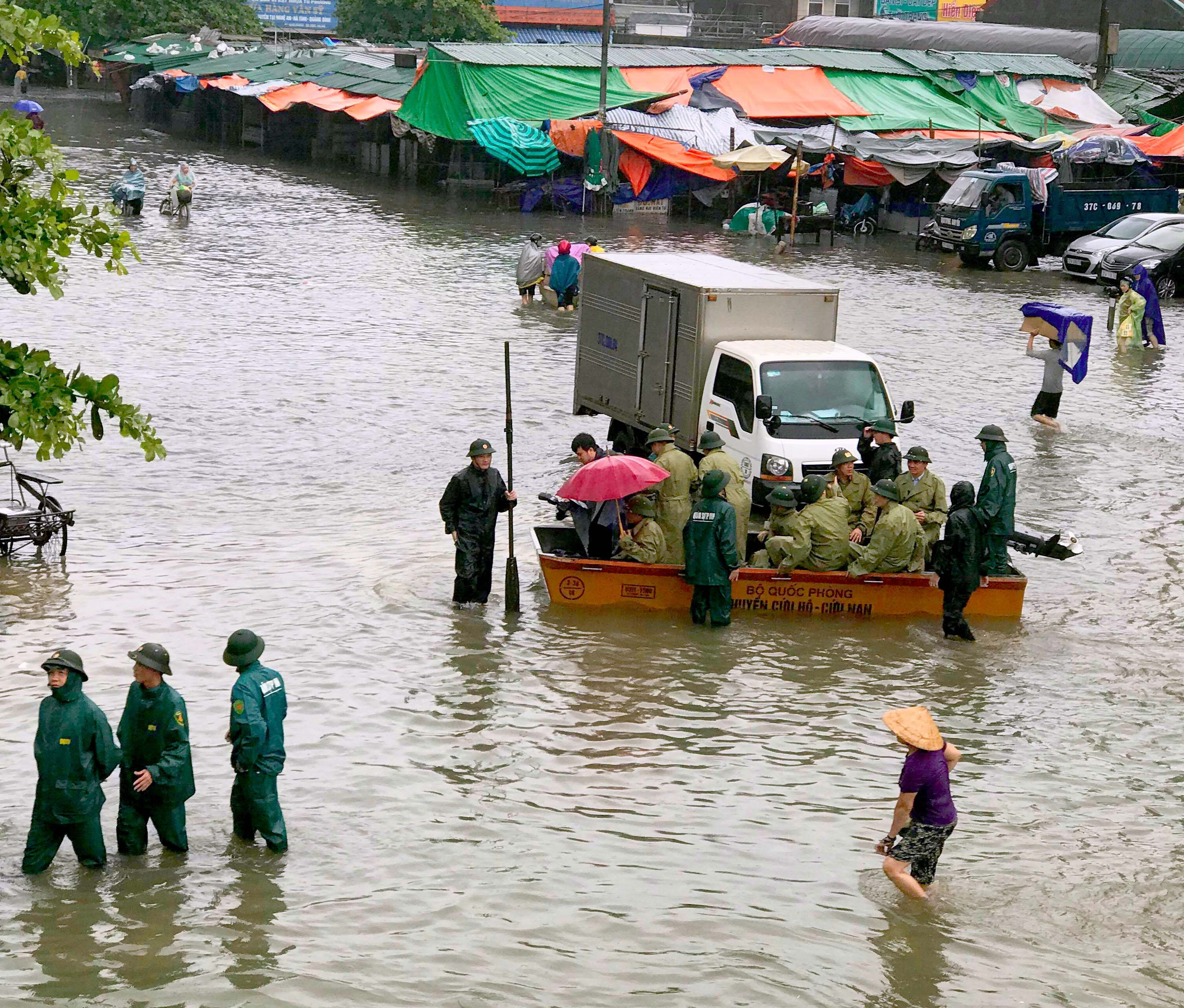 |
| Authorities had to use rescue boats to help people affected by flooding. Photo: Quang An |
According to Mr. Hoang Hong Khanh - Director of Vinh City Urban Infrastructure Management and Development Company, at 12 noon on October 16, the water level at the station rose rapidly, causing the risk of flooding 6 generators and the station's operating room. At that time, the water level in the operating room was more than 50cm. Therefore, the staff and workers of the pumping station had to use sandbags to block the door to prevent water from flooding the room and flooding the machines, and at the same time use a generator to operate the water pump from the operating room to the outside.
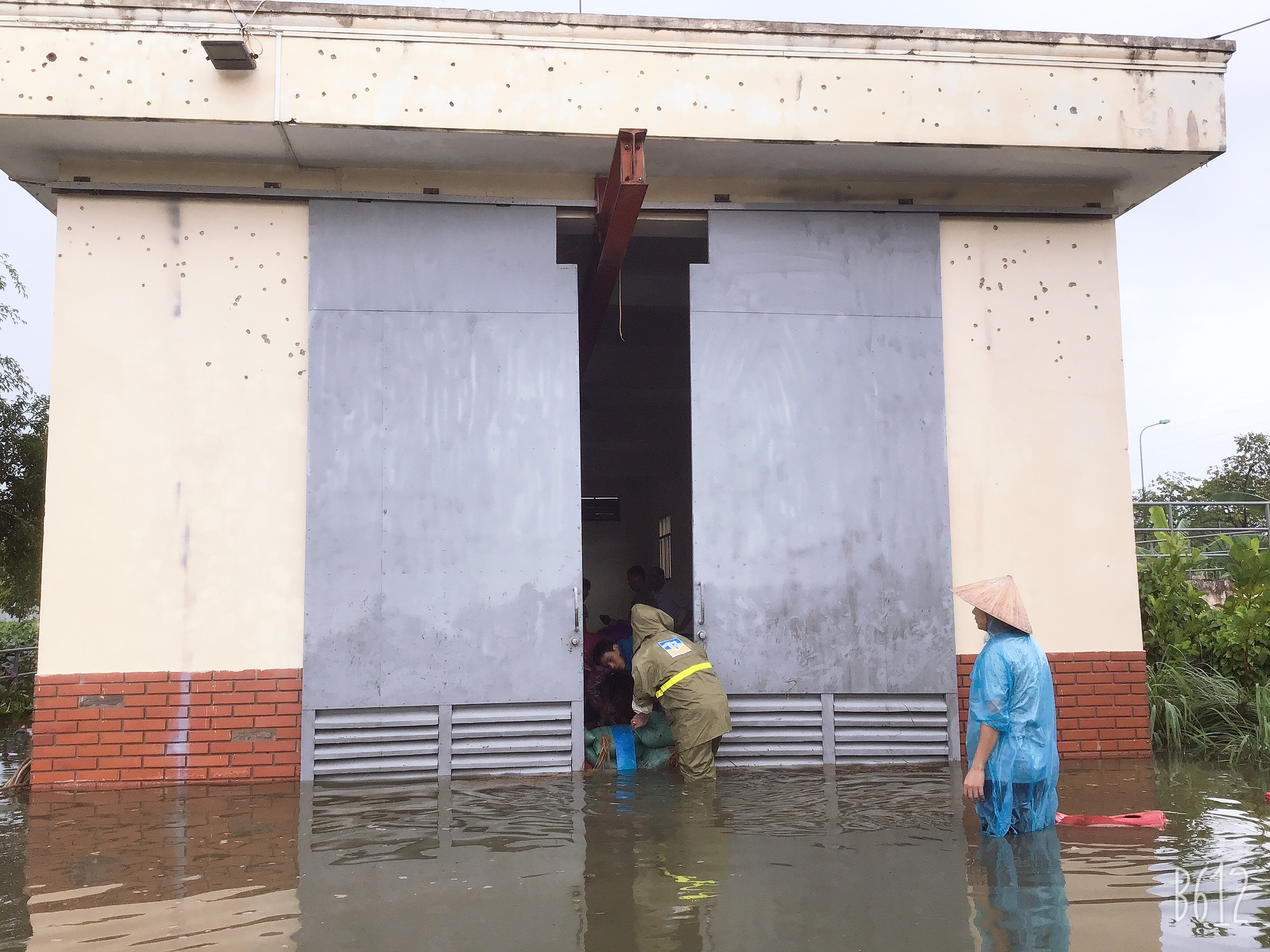 |
| Ben Thuy Pumping Station Operator House was flooded. Photo: PV |
Also at this time, rising water threatened to flood the transformer station supplying electricity to Ben Thuy Pumping Station. Therefore, the Electricity Company had to cut off electricity to the entire area using electricity from this station, including Ben Thuy Pumping Station. Electricity was only turned back on by the Electricity Company at 4:15 p.m. Due to the power outage, Ben Thuy Water Pumping Station had to temporarily stop operating from 12:00 to 7:00 p.m.
Ben Thuy pumping station serves to drain water for the areas of Ben Thuy ward, Truong Thi ward, part of Trung Do ward, Truong Thi ward, the area south of Nguyen Du street and part of Hung Dung ward; each hour the station pumps about 20 thousand cubic meters of water, if it is not stopped for 7 hours, the amount of water that can drain is about 140 thousand cubic meters. According to Mr. Hoang Hong Khanh, if it is not stopped for 7 hours, by about 5:00 p.m., the water will be drained, saving the city from flooding.
 |
| One of the only two drains draining water from Hung Dung fields to the regulating lake. Photo: NL |
Due to the shutdown, pumping and pumping to prevent flooding in the control room, the pumping station was not operational again until 7 p.m. Therefore, the station had to operate at full capacity until 1 a.m. on October 17, 2019.
Stuck in the "dyke" east of the city
Regarding flood prevention and drainage for the North and East of Vinh city, along the Ta Lam dike (Lam riverside road), there are four sluices: Rao Dung (Nghi Thai commune), Thuy San sluice, Hoi Cong sluice, Hoi Chua sluice, of which Rao Dung sluice has a large scale, up to 10 drainage gates. Every time there is a prolonged heavy rain, water in the North and East of the city (wards of Ha Huy Tap, Hung Phuc, Hung Dung, Truong Thi, Ben Thuy and communes of Nghi Phu, Hung Loc, Hung Hoa) naturally overflows to the fields of Ben Thuy, Hung Dung wards, and communes of Hung Loc, Hung Hoa and Rao Dung canal to drain through these four sluices.
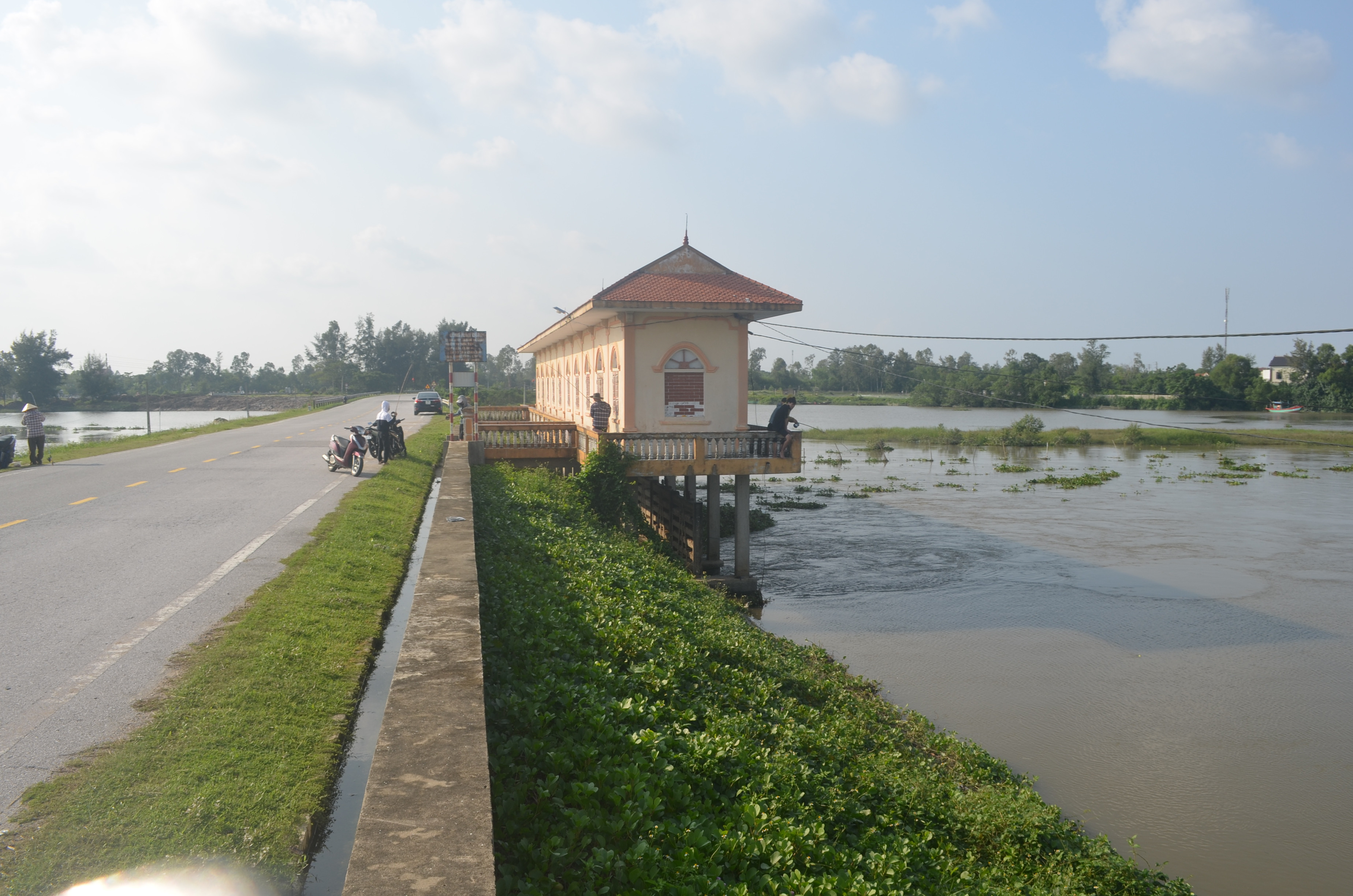
But now, when the regulating lake was built with the extended Nguyen Sy Sach road, it became like a low dike that hindered water drainage for the fields in Hung Dung and Ben Thuy wards and a part of the fields in Hung Hoa commune. Not only that, crossing the area of Hung Loc and Hung Hoa communes, a 35m road was invested in building connecting National Highway 46 to the Lam River road. This road, like another low dike, hindered water drainage. The reason is that on the two roads mentioned above, the drainage system between the areas is too limited. As with the extended Nguyen Sy Sach road, there are only two very small manholes with a width of only about 2-3m connecting the Hung Dung fields to the North Canal. As for the 35m road, there is only one drainage outlet under the bridge at the end of the regulating lake.
 |
| The 35m road is like a low dike. |
Regarding the limitation of water drainage from these two "dykes", Nghe An Newspaper reported in 2017 and 2018, when the fields in Hung Dung were flooded, people in Hung Dung ward and Hung Loc commune were flooded, facing many difficulties in production. During this period, Vinh City People's Committee, through checking the design documents of the Regulating Lake and the current status, also determined: Before constructing the Regulating Lake project, the road connecting National Highway 46 and the road along Lam River, the drainage ditches for Ben Thuy, Truong Thi, and Hung Dung wards flowed along the earthen ditches through Hung Dung Ward, Hung Loc Commune and poured into Rao Dung River, through Hoa Thai spillway, Hung Hoa Commune. Due to the construction of the Regulating Lake and 35m road, all the earthen ditches were filled up, obstructing the natural flow, causing local flooding in some areas, making agricultural production difficult.
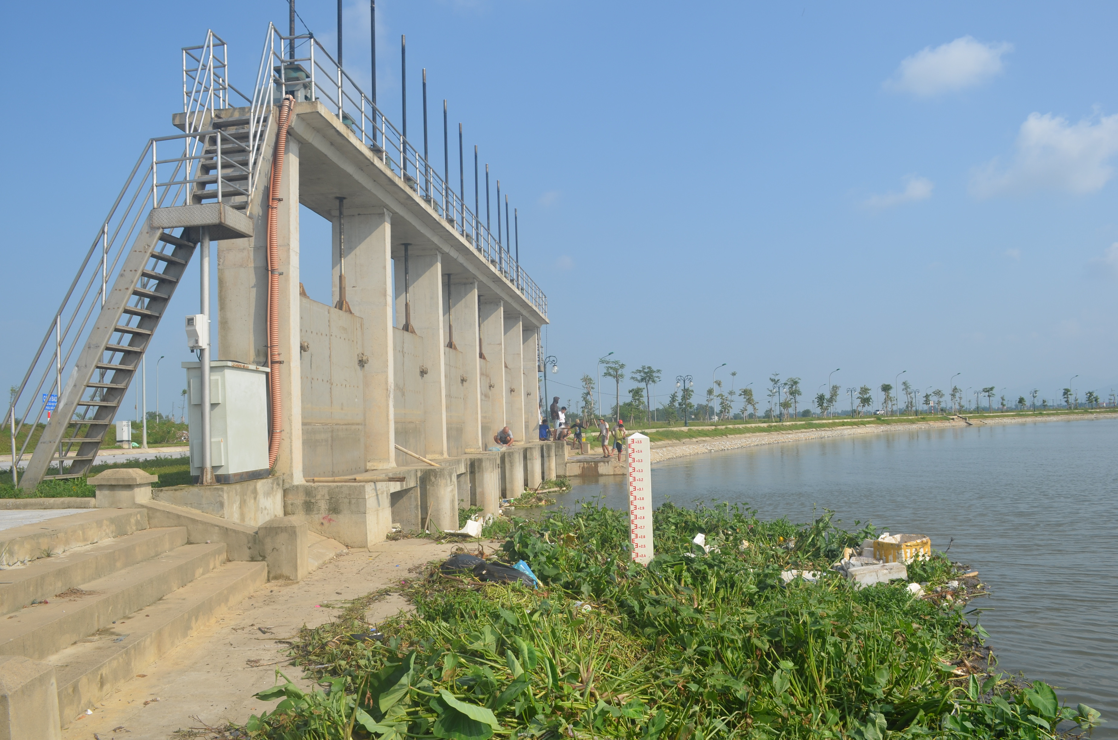 |
| The only drainage from the regulating lake to Rao Dung canal. Photo: NL |
The City Urban Management Department proposed a solution in Document No. 102/Ttr-QLDT dated February 21, 2017: “After completing the Regulating Lake, the earthen ditches previously located in the lake bed no longer exist; on the other hand, the designed water level in the lake bed is higher than the downstream water level of the drainage ditches for the wards of Truong Thi, Ben Thuy, and Hung Dung, so water cannot be drained into the regulating lake. Therefore, it is necessary to build a water collection ditch around the Regulating Lake down to the Hoa Thai spillway to collect water to drain the floodwater for the wards of Truong Thi, Ben Thuy, and Hung Dung and ensure drainage for agricultural production for the people…”.
There must be solutions to flood control.
Regarding the flooding situation in Vinh city, according to the report of Vinh City People's Committee sent to the Provincial People's Committee, on October 15-16, 2019, most of the traffic routes in the area were flooded from 30 to 60cm. Some deeply flooded routes such as: Le Ninh, Ly Thuong Kiet, Dang Thai Than streets, the communal house area behind Vinh market flooded an average of 1.2m; Le Hong Phong, Phong Dinh Cang, Nguyen Van Cu, Le Nin streets flooded an average of 0.9m... Quyet mountain had a landslide of 60m3 of soil causing 04 houses in Trung Do ward to collapse warehouses and fences. The landslide caused 01 house along canal No. 1, Cua Nam ward to collapse. Most of the blocks and hamlets in the wards and communes were flooded from 30 to 60cm. Some typical deeply flooded areas such as: Blocks 13, 14, 15 of Ben Thuy ward were flooded an average of 1.5m deep; Blocks 9 and 12 of Cua Nam ward, blocks 1, 14 and 15 of Trung Do ward were flooded to an average depth of 1.0m; blocks 12, 13, 14 and 15 of Nghi Kim were flooded to an average depth of 0.8m... Statistics show that throughout the city, 5,680 households had water entering their houses, 250 households had to be evacuated, 20,000 poultry died, 370 hectares of aquaculture ponds were flooded, 54 hectares of rice, 195 hectares of vegetables... estimated total damage was about 80 billion VND.
 |
| Rao Dung culvert in Nghi Thai commune. Photo: NL |
One thing worth noting in the recent historic flood is that the intervention of the province, city, and forces of agencies, units, and wards and communes in the area was early and decisive. However, it is necessary to point out the reality of flooding and such damages to see the need for effective solutions and urgent implementation. For Ben Thuy Pumping Station, the immediate solution is to increase capacity and need an independent power grid system. Also here, it is necessary to increase the capacity of the embankment and water reservoir.
On 35m roads and the extended Nguyen Sy Sach road, it is necessary to survey and accurately assess the existing drainage and flood drainage system...


")
.jpg "Lãnh đạo xã Tân Kỳ trao nhu yếu phẩm hỗ trợ bà con vùng ngập lụt")

.jpeg "Nghệ An: Chủ động chống ngập úng các xã, phường miền xuôi")