New information: Tropical depression in the East Sea, Nghe An floods above alert level 2
(Baonghean.vn) - At 1:00 a.m. on July 21, the center of the tropical depression was about 560km east-northeast of Hoang Sa archipelago.
According to the National Center for Hydro-Meteorological Forecasting,The center of the tropical depression is located at about 18.6 degrees North latitude; 116.9 degrees East longitude, in the North East Sea, about 560km East Northeast of Hoang Sa archipelago. The strongest wind near the center of the tropical depression is level 6 (40-50km/hour).level 8 jerk. The range of strong winds of level 6, gusting to level 8 is about 50km from the center of the tropical depression.
Dangerous areas in the East Sea in the next 24 hours: (strong wind level 6 or higher) from latitude 17.5 - 20.5 degrees North; east of longitude 115.0 degrees East.
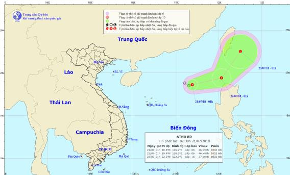 |
| The path and location of the tropical depression in the East Sea. Photo: National Center for Hydro-Meteorological Forecasting |
Forecast for the next 24 hours,The tropical depression is moving in the East-Northeast direction at about 15km per hour. At 01:00 on July 22, the center of the tropical depression was at about 19.4 degrees North latitude; 120.3 degrees East longitude, about 130km Northwest of Luzon Island (Philippines). The strongest wind near the center of the tropical depression is level 6 (40-50km/hour).level 8 jerk.
Due to the influence of the tropical low pressure circulation, the eastern sea area of the North East Sea has strong winds of level 6, gusts of level 8 and heavy thunderstorms. Rough seas.Disaster risk level: level 3.
Over the next 24 to 48 hours,The tropical depression moved northeast at about 15km per hour and gradually weakened into a low pressure area.
Besides, due to the influence of the tropical convergence zone with tropical depression combined with the strong southwest monsoon, during the day and tonight (July 21), in the Gulf of Tonkin, the North East Sea (including the Hoang Sa archipelago), the sea from Binh Thuan to Ca Mau, Ca Mau to Kien Giang and the Gulf of Thailand, there will continue to be heavy thunderstorms. During the thunderstorms, there is a possibility of tornadoes and strong gusts of wind.
The Central and Southern East Sea (including the Truong Sa archipelago), the sea area from Binh Thuan to Ca Mau continues to have strong southwest winds of level 5, sometimes level 6, gusting to level 8, waves 2-3m high; rough seas.Disaster risk level: level 1.
FLOOD INFORMATION ON RIVERS IN THANH HOA AND NGHE AN
1.Flood development
Floods in the downstream of Buoi River (Thanh Hoa) are changing little and are fluctuating at a high level; Ma River (Thanh Hoa) is receding; and the downstream of Ca River (Nghe An) is rising. Water levels at 4:00 a.m. on July 21 on the rivers are as follows:
Buoi River at Kim Tan: 10.82m, approximately level 2;
Ma River at Ly Nhan: 7.53m, below BĐ1;
Ca River at Dua: 22.18m, below BĐ2: 0.32m; at Nam Dan: 6.01m, above BĐ1 0.61m.
2.Forecast
In the next 12 hours, the water level on the Buoi River will continue to fluctuate at a high level, the Ma River will slowly decrease and may rise again, and the Ca River will continue to rise downstream. Water levels on the rivers are as follows:
Buoi River at Kim Tan is at 10.5m, 0.5m below BĐ2;
Ma River at Ly Nhan is below BĐ1;
Ca River at Dua is at 21.5m, 1.0m above BĐ1; at Nam Dan it is at 6.4m, 0.5m below BĐ2.
3.Warning
Today and tonight (July 21), due to the influence of the tropical convergence zone with a low pressure area developing in the North, the provinces of the North and North Central regions will have moderate rain, heavy rain and thunderstorms; especially the provinces of Lai Chau, Son La, Hoa Binh, Lao Cai, Yen Bai, Phu Tho, Thanh Hoa will have very heavy rain. Heavy rain in the provinces of the North and North Central regions is likely to develop complicatedly and last for many days to come, floods on rivers in Thanh Hoa and Nghe An will continue to fluctuate at level BĐ1-BĐ2, some places above BĐ2.
Flash flood, landslide and flooding warning:There is a high risk of flash floods and landslides in mountainous areas of Thanh Hoa and Nghe An provinces; flooding in low-lying areas continues to occur.Warning level of natural disaster risk due to floods, flash floods, landslides: level 2.


.png "Nghệ An chủ động ứng phó áp thấp có khả năng mạnh lên thành áp thấp nhiệt đới, mưa lớn, nguy cơ lũ quét, sạt lở đất")
