The Provincial People's Committee issued a decision approving the detailed planning task for both banks of the Vinh River.
(Baonghean.vn) - The People's Committee of Nghe An province has just issued a decision approving the detailed construction planning task at a scale of 1/500 on both sides of the Vinh City river.
Nghe An Provincial People's Committee has just issued a decision approving the detailed construction planning task at a scale of 1/500 on both sides of Vinh City River, a river that plays an important historical role in the city and is a highlight of Vinh City in the future.
Accordingly, the planning scope is about 82.0 hectares, of which: Area belonging to Vinh city is about 61.5 hectares; area belonging to Hung Nguyen district is about 20.5 hectares.
Location along both banksVinh River(from the center of the river to each side, the length of the river is about 7 km from Hung Chinh commune, Vinh city to Lam river) in the areas of wards: Hung Chinh, Vinh Tan, Trung Do, Hong Son, Cua Nam (Vinh city) and Hung Loi commune (Hung Nguyen district).
 |
| Document of Nghe An province. Photo: Tran Chau |
 |
| The task of planning both sides of Vinh River aims to concretize the general planning of Vinh city until 2030. Photo: Tran Chau |
The planning of both sides of Vinh River is determined to be the main landscape green area and water surface of Vinh City. Vinh City is invested in synchronous construction of landscape architecture space and technical infrastructure in a sustainable direction, ensuring regulation and supporting the effective operation of Vinh City's drainage system; Serving the entertainment needs of people in the area. The planning area has main functional areas, including: Water surface (Vinh River); Landscape green area combined with commercial services; technical infrastructure area.
Planning is made to specifyVinh City Master Plan, zoning plans for wards and communes in Vinh City, and the New Rural Development Plan for Hung Loi Commune have been approved. At the same time, it will reduce the risk of flooding, increase the ability to adapt to climate change, and improve environmental conditions for the city through the renovation and upgrading of the drainage system and Vinh Riverbank.
The planning also aims to strengthen the connection between the two banks of the Vinh River, the city center and other areas, to create a highlight for Vinh urban area; at the same time, expand the "golden" land fund in the south of the city.
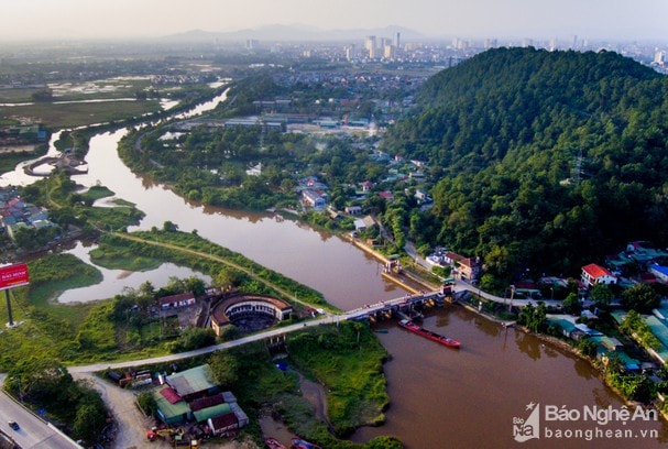 |
| Vinh River seen from above. Photo: Thanh Cuong |
The planning project has the task of investigating, surveying and collecting relevant data, plans and projects that have been established and approved in the design research area. Socio-economic forecasting, determining land use indicators, infrastructure, and technical infrastructure of the planning area.
Organize the planning of landscape architecture space, land use planning, technical infrastructure planning, urban design and strategic environmental assessment in accordance with the orientation of urban development adapting to climate change of Vinh City and the orientation of adjusting the general planning of Vinh City approved by the Prime Minister...
After issuing the planning task, Vinh city will carry out the planning task. Currently, the area around Vinh river is attracting many investment projects.


