Nghe An plans a new administrative center of Dien Chau district, over 32 hectares wide, in Dien Hoa commune.
(Baonghean.vn) - This is one of the contents of the Phu Dien Urban Master Plan (scale 1/10,000) recently approved by the Standing Committee of Nghe An Provincial Party Committee.
PHU DIEN URBAN EXPANSION HAS AN AREA OF 3,800 HA IN 9 COMMUNES AND TOWNS
The general planning project of Phu Dien urban expansion is established on an area of 3,800 hectares, with a planning period until 2040, vision to 2050 (first phase until 2030); including the entire administrative boundary of Dien Chau town; communes: Dien Phuc, Dien Tan, Dien Thanh, Dien Ngoc, Dien Ky, Dien Bich, Dien Hoa and a part of the South belonging to Dien Kim commune, Dien Chau district.
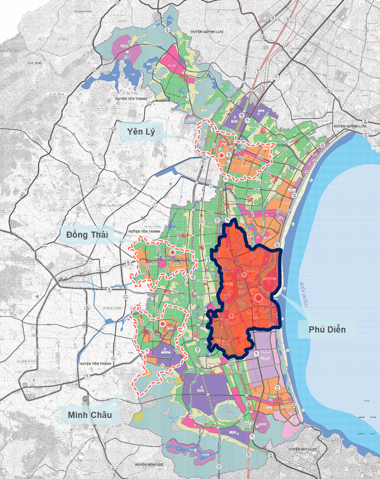
To the North, it borders the communes of Dien Hong, Dien Van and a part of the North of Dien Kim commune. To the South, it borders the communes of Dien Thinh, Dien Loc, Dien Tho. To the East, it borders the East Sea. To the West, it borders the communes of Dien Cat, Dien Quang, Dien Hanh, Dien Xuan, Dien Thap.
The general planning of Phu Dien urban expansion has a population of about 75,000 people in 2022 and about 98,000 people by 2040.
The planning project clearly shows the arrangement of administrative units and orientation of organization and development of urban space.
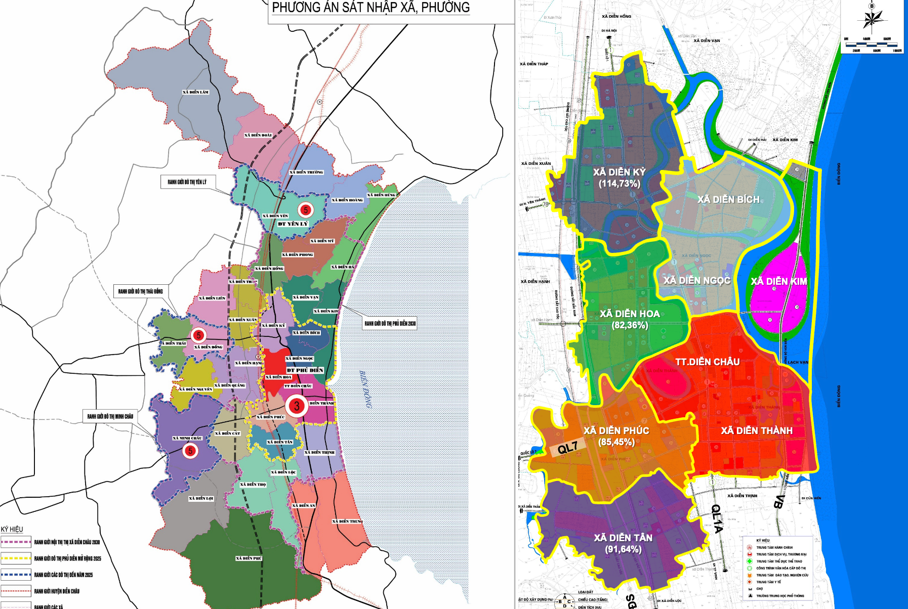
Of which, 4/8 administrative units under the planned plan will be merged, including: Merging Dien Thanh commune and Dien Chau town; merging Dien Ngoc commune and Dien Bich commune to form 2 new commune-level administrative units. Dien Ky, Dien Hoa, Dien Phuc, Dien Tan communes will remain the same. 6 administrative units after the arrangement under the plan will be upgraded to wards.
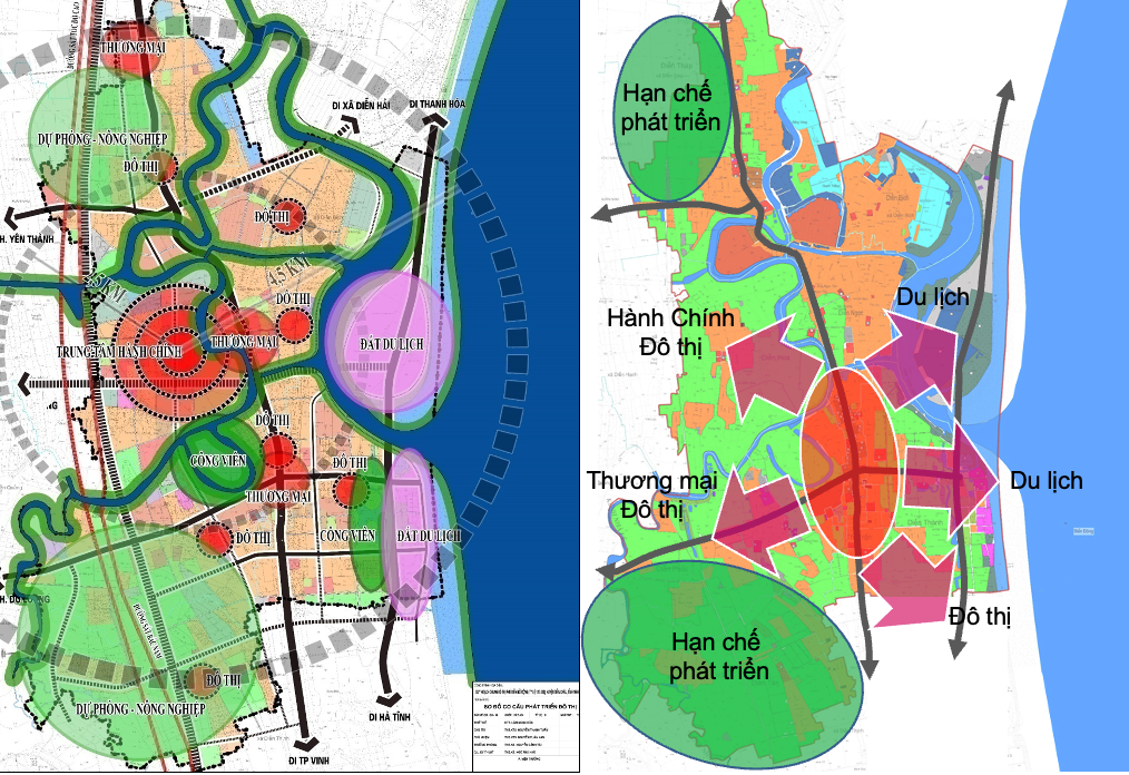
Phu Dien urban expansion is planned into 4 areas:
Area 1:Developing an urban administrative and service center, an area with concentrated urban administrative works, commercial services, and concentrated residential areas; including part of Dien Thanh and Dien Phuc communes in the North of National Highway 7 and Dien Hoa and Dien Ngoc communes (bordering Lach Van River in the West);
Area 2:Developing tourism services, an area concentrating on service, commercial, resort, entertainment and residential facilities; including part of Dien Thanh commune in the west of the planned 36m road and part of Dien Kim commune (within the planning boundary).
Area 3:Developing residential, urban service - industrial areas, is an area concentrating old and new residential areas combined with the development of industrial service works associated with the industrial area, urban service area in the North of the Southeast Economic Zone; at the same time, partly combining agricultural functions associated with land reserve to create resources for the next phase; including part of Dien Thanh commune, Dien Phuc commune in the West of Area 2 and the South of National Highway 7.
Area 4:Developing residential areas, traditional local commercial urban areas, associated with services on the economic corridor of National Highway 1 and both sides of National Highway 7B; including the entire Dien Bich and Dien Ky communes (North of Area 1).
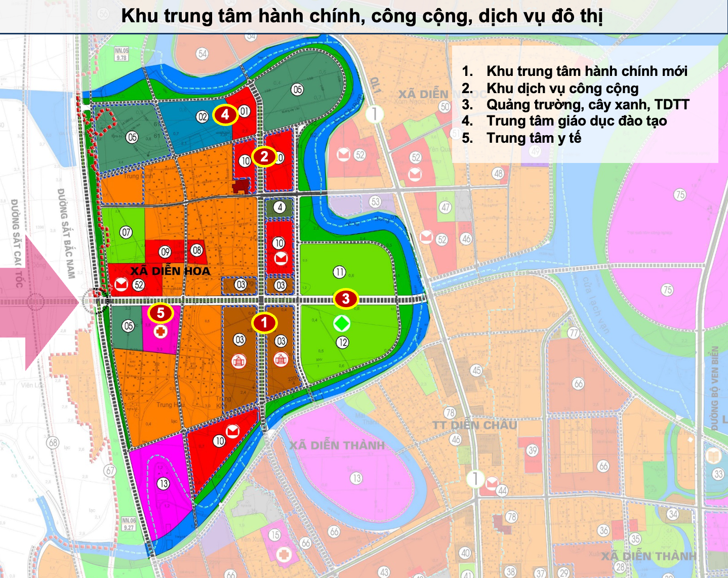
The planning project also clearly shows the spatial development orientation, including the planning of a new district-level administrative center and urban area in Dien Hoa commune. Land area 32.38 hectares, maximum construction density 40%, maximum height 10 floors.
Commune and ward administrative agencies are basically kept at their existing old locations; some new agencies are gradually built, expanded, and renovated to meet development standards and requirements. Maximum construction density is 40%, maximum height is 4 floors above ground and 2 basements.
CREATING AN URBAN CORE ZONE AS A PREMISE FOR DIEN CHAU DISTRICT TO BECOME A TOWN BEFORE 2030
According to the planning project, the expanded Phu Dien urban area is a service urban area located in the center of Dien Chau district; with the function of being a center of economy - culture, trade, marine eco-tourism and cultural and historical tourism; is the core area of the urban center when Dien Chau town is formed with administrative functions, commercial services, resort tourism services, and industrial services.
This is a traffic hub connecting the economic corridor of the Northwestern districts with coastal districts and Vinh city along the two axes of North-South (National Highway 1; North-South railway; connected to the North-South expressway) and East-West (National Highway 7). The objective of the planning project is to concretize the orientation of the National Urban System Master Plan; Nghe An Provincial Planning for the period 2021-2030, with a vision to 2050 and the approved orientation of the construction planning of Dien Chau district for the period 2021-2030, with a vision to 2050.
At the same time, build and develop Phu Dien urban area in the direction of a commercial, industrial, and marine eco-tourism service urban area with modern and synchronous infrastructure meeting the criteria of a type IV urban area before 2025, creating a premise for Dien Chau district to become a town before 2030.
At the same time, exploiting the potential and advantages of the central area of Dien Chau district to develop Phu Dien urban area in a sustainable direction, in accordance with the requirements of green growth and adaptation to climate change; enhancing the role, position and location advantages of Phu Dien urban area, making an important contribution to the overall development of Dien Chau district and Nghe An province, creating new development values to increase competitiveness in the region.

The planning project also serves as the basis for determining the scope of urban development space expansion, implementing zoning and detailed planning projects, establishing investment projects and serving as the legal basis for construction management according to the planning.
After the Provincial Party Standing Committee approved, the Phu Dien Urban Master Plan (scale 1/10,000) continued to be completed and approved in accordance with regulations.
In recent years, Dien Chau district has focused on building social infrastructure systems, attracting investment in many dynamic projects. Compared with the criteria for a type IV urban area, it achieved 61.55/100 points (40/54 criteria).
.jpg "Bí thư Tỉnh uỷ Nguyễn Khắc Thận chủ trì phiên họp Thường trực, Ban Thường vụ Tỉnh uỷ")


.jpg "Ban Thường vụ Tỉnh ủy Nghệ An khoá XX họp phiên thường kỳ tháng 9")
.jpg "Ban Thường vụ Tỉnh ủy Nghệ An định hướng sắp xếp đơn vị sự nghiệp công lập, trường học, cơ sở y tế trên địa bàn tỉnh")


