Warning: Storm No. 4 - Bebinca moves fast, 370km from Vinh city (Nghe An)
(Baonghean.vn) - According to the 9am news this morning (August 16) of the National Center for Hydro-Meteorological Forecasting, this morning, storm No. 4 moved quickly (15-20km/hour) in the West-Southwest direction. At 7am at Bach Long Vi, strong winds of 19m/s (level 8), gusts of 26m/s (level 10) were measured.
At 8 o'clock,The center of the storm is located at about 20.2 degrees North latitude; 108.3 degrees East longitude, 180km from Mong Cai, 230km from Nam Dinh, 370km from Vinh. The strongest wind near the center of the storm is level 9 (75-90km/hour).level 11. The range of strong winds of level 6, gusting to level 8 is about 110km from the center of the storm.
Forecast for the next 24 hours,The storm is moving west southwest at about 10km per hour.From midnight tonight to noon tomorrow (August 17), the storm center with strong winds of level 8, gusts of level 10 will directly affect the provinces from Quang Ninh to Nghe An.
At 7:00 a.m. on August 17, the storm center was located at about 20.0 degrees North latitude; 105.7 degrees East longitude, right on the mainland of the provinces from Thai Binh to Thanh Hoa. The strongest wind near the storm center was level 8 (60-75 km/h).level 11. The range of strong winds of level 6, gusting to level 8 is about 100km from the center of the storm.
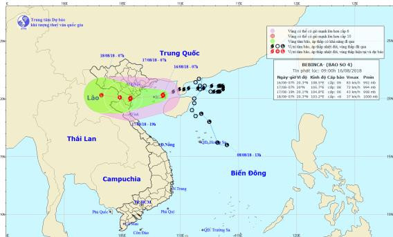 |
| Storm path and location. Photo: National Center for Hydro-Meteorological Forecasting |
Due to the influence of the storm, in the Gulf of Tonkin there will be stormy rain, strong winds of level 6-7, and areas near the storm's eye will have winds of level 8-9.level 11. In Bach Long Vi island district, strong winds level 8-9, gusting to level 11; in Co To island district, strong winds level 7-8,level 10Waves in the Gulf of Tonkin are 4-6m high and the sea is very rough.
Dangerous areas at sea in the next 24 hours (strong wind level 6 or higher): the entire sea area north of the Gulf of Tonkin (north of latitude 19.0 degrees North).
Over the next 24 to 36 hours,The storm is moving west at about 10km per hour.move inland and weaken into a tropical depression. At 7:00 p.m. on August 17, the center of the tropical depression was at about 20.1 degrees North latitude; 104.8 degrees East longitude, on the Vietnam-Laos border area. The strongest wind near the center of the tropical depression was level 6 (40-50 km/h).level 8 jerk. The range of strong winds of level 6, gusting to level 8 is about 60km from the center of the tropical depression.
Due to the influence of the storm, from tonight on the mainland coastal areas of Quang Ninh, Hai Phong, Thai Binh, Nam Dinh, Ninh Binh, Thanh Hoa, Nghe An provinces, the wind will gradually increase to level 6, from early tomorrow morning it will increase to level 7.level 9; Thai Binh, Nam Dinh, Ninh Binh, and North Thanh Hoa have strong storm winds of level 7-8,level 10.
Over the next 36 to 48 hours,The tropical depression moved in a West Northwest direction, about 10km per hour, went inland and weakened into a low pressure area.Storm disaster risk level: level 3.
FLOOD, FLOOD AND LANDSCAPE WARNING IN THE NORTHERN MOUNTAIN REGIONS AND NORTH CENTRAL REGIONS
From now until August 18, in the Northern and North Central provinces, there will be heavy to very heavy rain (rainfall of 250-350mm/period), the focus of very heavy rain will be in the Northeast region, the Northern Delta and midlands, the provinces of Son La, Hoa Binh, Thanh Hoa, Nghe An; in particular, Hoa Binh and Thanh Hoa will have the possibility of especially heavy rain (400-500mm/period).
Warning:From today until August 18, in the North and North Central regions, there will be a flood, the flood amplitude on the Red-Thai Binh river system, Hoang Long river will be from 2-4m; rivers in Thanh Hoa, Nghe An will be from 3-7m.
During this flood season, the flood peak on the Da River, Thao River, Hoang Long River, Bui River and Ma River is likely to reach level 2-3, while the Buoi River (Thanh Hoa) will reach level 3 and above 3; the Thai Binh River will be at level 1. Warning level of natural disaster risk due to floods and inundation: level 1-2.
There is a very high risk of landslides and flash floods in the mountainous areas of the North and North Central regions, especially in provinces such as: Lai Chau, Dien Bien, Son La, Hoa Binh, Yen Bai, Phu Tho, Quang Ninh, Lang Son, Cao Bang, Thanh Hoa, Nghe An.
Flooding in low-lying areas in the Northern Delta region and in urban areas of the following provinces and cities: Hoa Binh, Hanoi, Ninh Binh, Phu Ly, Nam Dinh, Ha Nam, Hung Yen, Hai Duong, Quang Ninh, Hai Phong, Thanh Hoa, Nghe An.
Warning level of natural disaster risk due to flash floods and landslides in mountainous areas of the North and North Central regions: level 2.


